Bannockburn Sluicings, Cromwell, NZ


The right (east) side of the loop is on an impact track. The poled track continues further east, to the right of the word ‘Track’.
Screenshots of the NZ topographic map are licensed as CC BY 4.0 by Toitū Te Whenua Land Information New Zealand (LINZ).
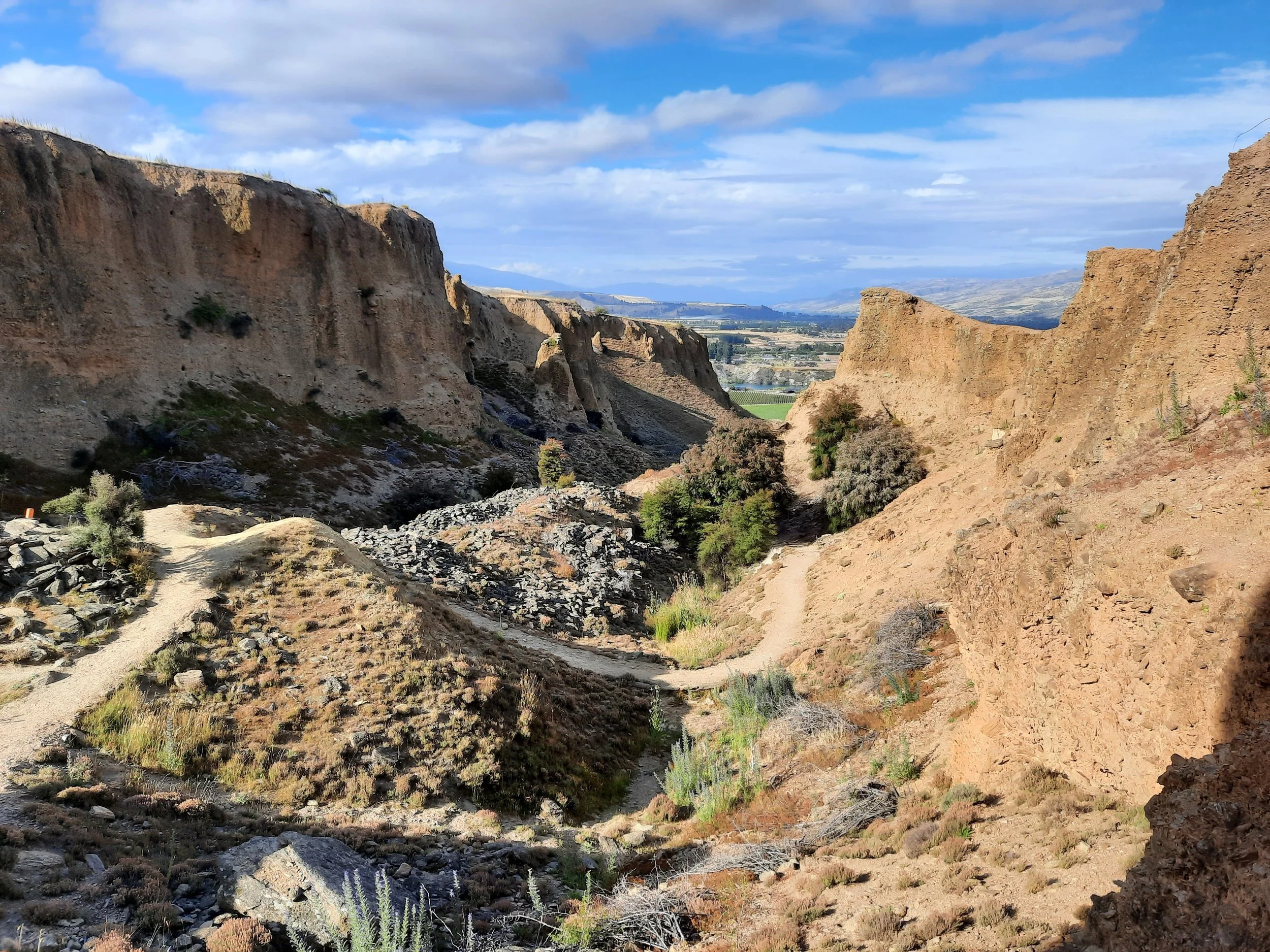
Bannockburn Sluicings is a former gold-mining site next to Cromwell, Central Otago in South Island. A loop track through it makes for a short walk; I descended the rim of the valley off-track, which made it a bit more like a hike, but only for a few minutes.
This walk can be extended with the Long Gully Loop Track.
Time
DOC estimates that it takes around 90 minutes. AllTrails users report an average of 70 minutes.
Including breaks, my route involving the shortcut took around 100 minutes. These were unusually long breaks.
Route
The trailhead is a medium-sized dirt parking lot. Shortly after the trailhead, the track forks. At a higher elevation, the tracks meet to make a loop. DOC reports that it’s 3.5km, while AllTrails reports 3.9km.
On the advice of a hiker I met at the trailhead, I went counter-clockwise. She told me that this would save the steeper part for the ascent. However, I took a shortcut descent, so I didn't get to compare my ascent with the official descent. You should probably assume she was right.
The track leaves the main valley and ascends through a canyon between unusual cliffs, created by miners during the Central Otago gold rush. DOC tells us that:
Kilometres of channels known as ‘water races’ were hand-dug to pipe water downhill from the dam above. The water was then blasted under pressure to break down the terraced gravels to free the gold – a technique known as hydraulic sluicing.
The cliffs are more remarkable than most landforms to be seen amidst the monotony of Central Otago.
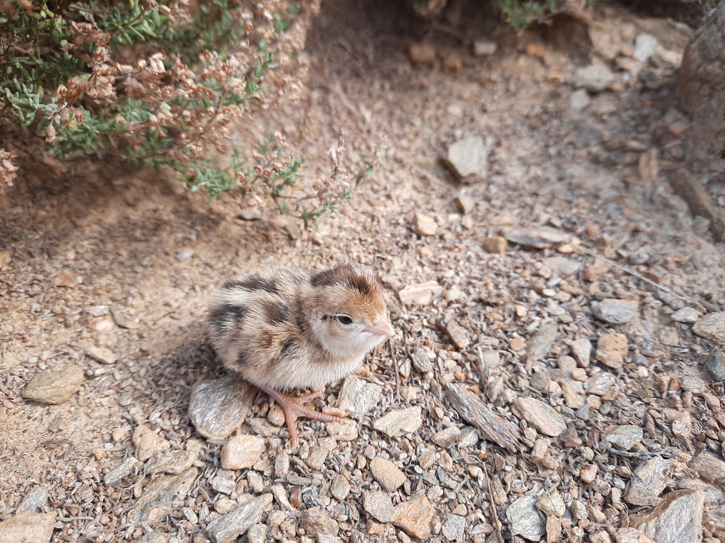
On the floor of the canyon, I found some California quail, including one very confused chick that ran up to me. There are a number of caves, but I couldn’t tell whether the quail lived in them. Do they do that? Does anything else live in them?
The track continues on a terrace above the canyon, winding through fields of wildflowers. The bees pollinating the blueweed (Viper's bugloss) and the magenta thistle were the highlight of the walk for me. I spent a long time trying to get non-blurry photographs by holding the stems of the flowers still against the wind with one hand, then resting my smartphone against the arm of that hand.
The bees look like European bumblebees, rather than native bees. If that's true, then all five of the most interesting things on the hike - sluiced cliffs, quail, bees, thistle, blueweed - weren't present just two centuries ago!
I took a shortcut for my descent. It was a steep, loose impact track, which is probably vulnerable to landslides during and after rain. I recommend following the track instead. Once I reached the floor of the main valley, it was an easy walk - still on an impact track - back to the loop track, near its fork.
If 1 is an easy track, and 4 is using hands and feet on exposed rocks, I give this 2 at worst, but mostly a 1, on official track. My shortcut descent was a 3.


Other pages about this walk (on the official track)
Pages about other hikes involving this walk
Pages about nearby hikes
Devil’s Creek Track (not to be confused with the track of the same name near Queenstown and Arrowtown)
https://hikingscenery.com/mt-pisa-via-tinwald-burn-ridge-track/