Mt Alford, Methven, NZ


Screenshots of the NZ topographic map are licensed as CC BY 4.0 by Toitū Te Whenua Land Information New Zealand (LINZ).
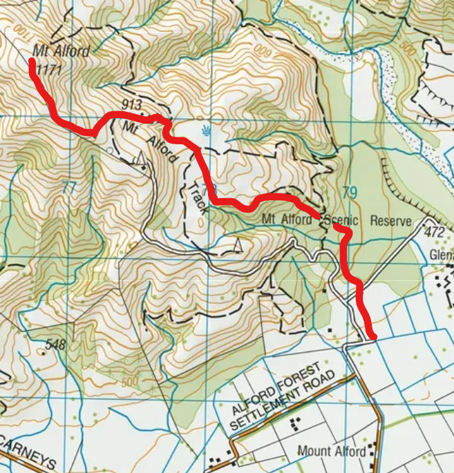
Mt Alford (1171m) is a mountain next to the Canterbury Plains in Canterbury, South Island. The Mt Alford Track ascends to its summit through forested conservation land, then open farmland and open conservation land. My medium-length hike to the summit was one of the least worthwhile hikes I have done in South Island, primarily due to the muddy track in the forest.
The view from the summit is similar to that from the summit of nearby Mt Somers.
Time
DOC estimates that it takes 3 hours to reach the summit.
The hike took me about 2:05 each way, excluding break on the summit.
Route
DOC reports that the trail is 4.6km each way, while Wilderness Magazine reports 4.26km each way, and 753m of elevation gain.
I parked in the small parking lot at the end of Alford Forest Settlement Rd, then passed through a few farm gates to enter the forest. This conservation land is Alford Scenic Reserve, containing a small part of the large Alford Forest spread across multiple mountains. The track through the forest alternated between fine and muddy sections. Several of the muddy sections were challenging, especially one that traversed a slope with heavy tree cover on the uphill side. My hike was on a sunny day, but I guess the heavy tree cover kept the track from drying out after whenever it last rained. I would not have done the hike had I known about the mud.
Exiting the forest, I passed through a farm gate or two into grassy/tussocky farmland, and then at least one more gate to reach the higher-level conservation tract. Two of these gates were elevated square gates that an older or inflexible hiker might feel uncomfortable getting through. The second elevated square, leading into the upper conservation tract, didn’t have a sign on its downhill side. See photo 12 below. But the picnic table just beyond it is a clear indicator for hikers.
Ascending through the upper conservation land, I lost the impact track, despite the occasional orange pole. Instead I walked uphill next to the fence on the left. This brought me to the broad summit. On the way down, I was more able to spot the impact track.
If 1 is an easy track, and 4 is using hands and feet on exposed rocks, I give this track a 3 at most, but mostly a 2.


Hunting
The lower and upper conservation tracts are hunting areas. Hunters are forbidden to “discharge firearms near tracks, huts, campsites, road-ends or any other public place.” I have hiked in dozens of NZ hunting areas, and only passed hunters three times - this wasn’t one of those hikes.
Here is the DOC topomap with all hunting areas visible.
Other pages about this hike
Pages about nearby hikes
Woolshed Creek circuit, next to Mt Somers
Mt Somers
https://www.alltrails.com/trail/new-zealand/canterbury/pudding-hill-stream-route