Dome Summit on Mt Ruapehu, Tongariro, NZ


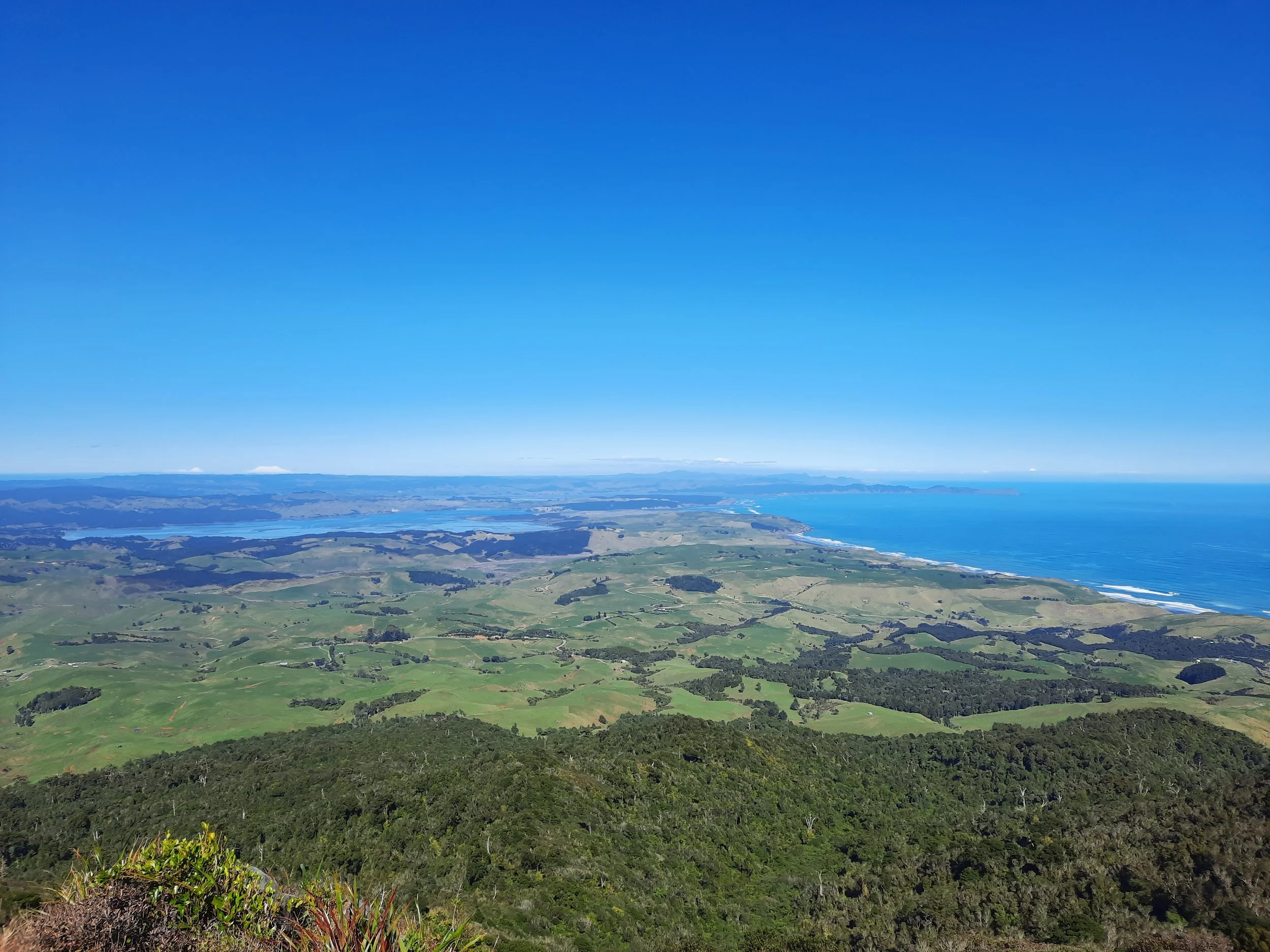
Mt Ruapehu is the highest mountain on North Island. It is in the Tongariro National Park, near the straightforwardly named small town of National Park (Waimarino).
The northern slopes contain the tourist village of Whakapapa, location of the DOC office, and the ski village of Iwikau further uphill. Iwikau is about 10 minutes from Whakapapa village and 20 minutes from National Park.
Iwikau is the location of my trailhead. I hiked through Whakapapa ski field to Dome Summit (2672m), which is across the crater lake from the high summit, Tahurangi (2797m). I don’t know why they call Dome a ‘Summit’ rather than a ‘Peak’.
Mt Ruapehu is an active volcano. GeoNet provides updates on how much volcanic unrest there is, while DOC maps exclusion zones of varying size depending on the estimated risk.
Time

The Tongariro area, with Mt Tongariro, Mt Ngāuruhoe, and Mt Ruapehu, from north to south.
Screenshots of the NZ topographic map are licensed as CC BY 4.0 by Toitū Te Whenua Land Information New Zealand (LINZ).
Including breaks, it took about 4 hours to hike up to the outer edge of the crater, around 30 minutes to visit Dome Summit and enjoy the view, and about 3 hours to hike down to the Sky Waka gondola.
Route
Iwikau village was nearly deserted when I visited in summer. I parked near the main parking lot and walked up the road. I started too early to take the Sky Waka gondola part-way up, but I did take it part-way down. The upper station was a pleasant place for lunch.
AllTrails reports 1041 meters of elevation gain over 10.3 kilometers return from Iwikau, or 633 meters gained over 5.8 kilometers return from the top of the Sky Waka.
The route through Whakapapa ski field is a mixture of rocks, which are unpleasant to walk on, and softer soil, which is much better. It is safer to hike on high ground where possible, in case of a lahar (volcanic mud flood). I won’t attempt to describe my route through this complex and hazardous area. Sources I consulted, in no order:

The green dot is the trailhead. The red dot is the top of the Sky Waka gondola. The purple dot is where I turned around, at Dome Summit. The high summit is further south, Tahurangi.
https://www.alltrails.com/explore/recording/ruapehu-crater-lake-4f1927f
https://shoesyourpath.com/climbing-mt-ruapehu-summit/ (also available in French)
https://www.moonhoneytravel.com/hiking-to-mount-ruapehus-crater-lake-without-a-guide-new-zealand/
https://hikingtheworld.blog/2020/03/08/mount-ruapehu-crater-nz/
This blog post has a useful slider function, showing the topomap and the satellite map. Scroll down for it.
The volcano was under DOC’s risk management stage A, the lowest of three stages. This meant that the exclusion zone around the hazardous, lahar-belching crater lake was the 700-meter one shown in this map. Dome Summit is mere seconds inside the zone. Otherwise, I kept out of the zone. There are fine views of the crater lake and Tahurangi (the high summit) without going quite as far as Dome Summit.
The volcano is not the only risk. It’s possible to have a normal winter mountaineering accident on Dome Summit, which looks benign in summer and perhaps does in winter too.
The above sources are correct about the risk of getting bluffed on the way down. I walked exactly where I shouldn’t have, and got bluffed. Luckily I found an easy out, where I just had to slide down a small rock face. This saved me from re-ascending, or summoning my giant eagle. (Each Eaglesfield has their own giant eagle, which rescues them and deposits them safely, in a field.)
If 1 is an easy track, and 4 is using hands and feet on exposed rocks, I give this track a 3 overwhelmingly. The somewhat gravel-like mound containing Dome Summit is a 2, as are sporadic easier stretches of the rocky ascent.


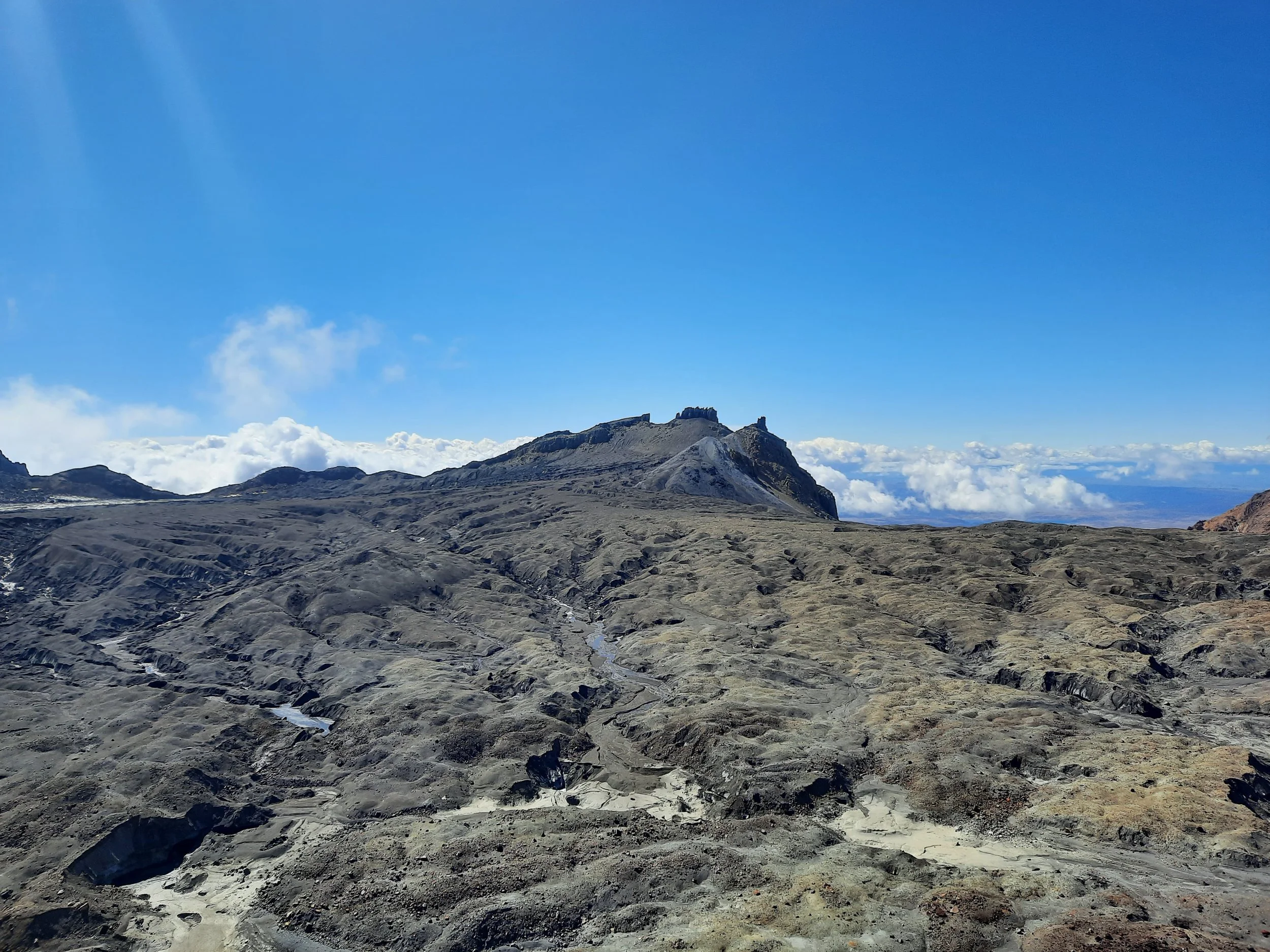


From Dome Summit. Paretetaitonga (right) appears higher than the high summit Tahurangi (center) because it’s a panorama. At left, Pyramid Peak, and Ringatoto Peak behind it.

Tukino Peak, left. Te Heuheu is obscured by cloud. Cathedral Rocks, center. Dome, right. Tahurangi, far right. The most Mordor-like of the photos, and the most interesting to me.

See Route section for links to other blog posts about this hike.
Volcano
https://www.doc.govt.nz/globalassets/documents/about-doc/role/managing-conservation/vocanic-risk/ruapehu-volcanic-risk-management-map.pdf (composite map of exclusion zones varying by level)
https://www.youtube.com/watch?v=B1n8O84TFc0 (government-sponsored lahar safety video)
Pages about hiking to Tahurangi (the high summit)
https://www.alltrails.com/trail/new-zealand/manawatu-wanganui/tahurangi-summit-via-turoa-ski-area
https://www.youtube.com/watch?v=ZW8FdemJotM (snowboarding)
Pages about hiking to the Summit Plateau (on the other side of Dome Summit)
Pages about hikes on lower slopes of Mt Ruapehu
https://adventuremagazine.co.nz/it-isnt-just-about-the-snow/ (Skyline Ridge Walk - the only other hiker I saw was heading here)
https://www.visitruapehu.com/see-do/walking-hiking/day-walks
Local history
https://nzhistory.govt.nz/culture/the-tangiwai-railway-disaster (caused by a Ruapehu lahar in 1953)