Black Peak, Glenorchy, NZ


Mt McIntosh (1701m) is a day-hike done from an obscure highway trailhead near Glenorchy, Otago, South Island. The trailhead is a little north along the highway - toward Glenorchy - from the Mt Judah (Whakaari Conservation Area) parking lot.
Black Peak (1989m) is the next named peak uphill of Mt McIntosh, and thus makes a longer day-hike. I skipped the summit of Mt McIntosh in favor of more-or-less summiting Black Peak.
To the south are the Mt Judah-Heather Jock Loop-Mt-Alaska hikes. They are accessed directly from the Mt Judah parking lot, without any highway walking. I enjoyed Mt Alaska more than Black Peak, partly because it was less strenuous.
There is an alternative route combining aspects of the above: starting on the Mt Judah track from the Mt Judah parking lot, then crossing the Buckler Burn to ascend Mt McIntosh (before pushing on to Black Peak). See one blogger’s photo of crossing the Buckler Burn before you decide on doing this! A friend of mine decided to turn back there, although she successfully crossed on a later date. At its worst, it can be more than a meter deep.
All of these hikes are located in Whakaari Conservation Area.
Not to be confused with Black Peak (2289m) in the Harris Mountains near Wānaka, which I enjoyed more, nor the obscure Black Peak on Mt Earnslaw (within view of this hike).
Time

Screenshots of the NZ topographic map are licensed as CC BY 4.0 by Toitū Te Whenua Land Information New Zealand (LINZ).
This hike took me a little over 13 hours, including breaks.
Reaching the summit took around 8 hours.
Returning took around 5 hours.
It was my longest hike; it is now my second longest. Doing this as a day-hike was a bit beyond my reasonable fitness expectations. The nearby Mt Alaska, which I did in 11 hours two days prior, was a better way to scratch my “very long hike” itch.
Wilderness Magazine reports that the alternative route to Black Peak - starting on the Mt Judah track and crossing the Buckler Burn - takes 11-14 hours.
Route
From Mt Judah parking lot, I walked 5-10 minutes along the highway toward Glenorchy, located a hard-to-spot gap in the trees (see photo below), and began crossing a farm.
This farm route avoids crossing the Buckler Burn, but it does require crossing a farm stream, which is much smaller than the Buckler Burn. One of my feet slipped into the stream on the return crossing; my Outdoor Research Crocodile gaiters kept my sock dry.
Not long after that, the challenge began: 600 steep meters up to Point 1203, on Mt McIntosh’s western spur. The DOC workers in Queenstown warned me about the steepness, and you can see it in photos below. It took me around 1 hour 30 minutes. This steep section is probably one of the reasons that crossing the Buckler Burn is the more popular ascent route.
From Point 1203 until the slopes below Black Peak, it is mostly an easy undulating route. The exception is the steep, somewhat loose slope between Point 1342 and Point 1244. When tired, on the return journey, ascending it is not fun.
Edward at HikingScenery.com helpfully took a photo of the fork where the Black Peak track goes left and the Mt McIntosh Hut track goes right.
On the slopes below Black Peak, I encountered some snow covering parts of the switchbacks. Hiking up the switchbacks would probably be straightforward without snow. However, I moved slowly in snow, because there are a few disused mine entrances along the track to the peak. I didn’t know their exact locations, and didn’t want to slide into one.
I did not quite reach the true summit of Black Peak. On the topomap there is an adjacent high point, just to its west. (It is covered by the red route I drew over my topomap screenshot.) I accidentally climbed to that false summit instead. Both the false summit and the true summit involve a few meters of rock climbing.
If 1 is an easy track, and 4 is using hands and feet on exposed rocks, I give this track a 4 for a few meters of rock climbing to my false summit. I give a 3 to the farm stream crossing, the long steep section leading up to Point 1203, and the ascent from Point 1244 to Point 1342. The rest, without snow, is a 1 or a 2.


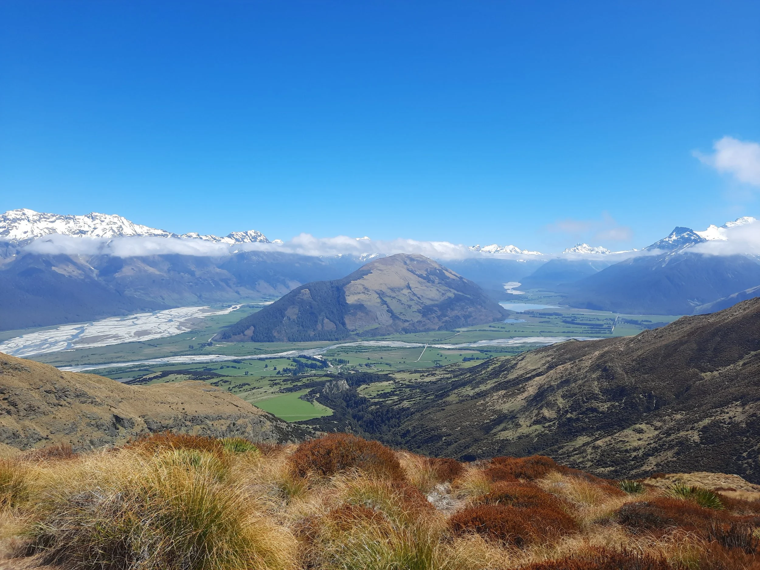


Left side: Far left (southeast) is Mt Butement, with some snow. To its right, higher, and with more snow, is Mt Larkins. Below and to the right of Mt Larkins is Mt Alaska, hard to spot without zooming in. It has only a small amount of snow on it. It is about 335 meters lower than Mt Larkins.
Center-left: the brown hill is the ridge leading to Mt McIntosh (which is hidden). Center: Precipice Hill (dark), and behind it Mt Alfred/Ari (lighter).
Right side: Snowcapped at center-right (north) is Temple Peak, rising from Precipice Hill. Far right (east) is the nearby true summit of Black Peak.
Hunting
Starting a little before the peak of Mt McIntosh, the rest of the route is in a hunting area. Hunters are forbidden to “discharge firearms near tracks, huts, campsites, road-ends or any other public place.” I have hiked in more than 30 hunting areas, and only passed hunters twice - this wasn’t one of those hikes.
Here is the DOC topomap with all hunting areas visible.
I can’t find any other pages about ascending to Black Peak by my route. The below pages all overlap with part of my route.
Ascending Mt McIntosh by my route
I walked a clockwise loop up Mt McIntosh Track, and connected across to come down the Mt Judah Track. If it hasn’t or isn’t raining I’d recommend this direction as Mt McIntosh Track is steep and slippery, relatively easier to climb up than to come down.
Jonty mentions rain because it would make crossing the Buckler Burn unsafe.
Ascending Black Peak via the Mt Judah/Buckler Burn route
https://www.youtube.com/watch?v=rgY-tAi3Zek (descending by my ascent/descent route)
https://backcountryhijinks.wordpress.com/2016/08/31/freehold-loop-and-black-peak-20th-21st-dec-2014/ (descending by my ascent/descent route)
https://bencollinsoutdoors.com/2014/01/25/new-zealand-part-iii-climbing-black-peak/
Ascending Mt McIntosh via the Mt Judah/Buckler Burn route
Local info
Miners in the Clouds: A Hundred Years of Scheelite Mining at Glenorchy, by Julia Bradshaw. A boy poses with his father, a miner, on the bookcover. That boy is grown up now, and on Bookabach.co.nz, you might be able to stay at the Glenorchy bach (holiday home) that he owns. Look closely at the map of Black Peak, and you will be able to spot their hut.


