Black Peak via Treble Cone, Wānaka, NZ


Black Peak (2289m), Treble Cone (2058m), and End Peak (2100m) form a mountain chain in the Harris Mountains of Otago, South Island. Hikers can reach Black Peak (going northwest) and End Peak (going south) along a ridge from Treble Cone ski field, around 40 minutes by car from Wānaka. The summit of Treble Cone is only accessible to climbers.
This page is about my group’s hike from Treble Cone to Black Peak and back; we didn’t visit End Peak. The ridge is mostly public land but crosses about 2.5km of land owned by The Branches Station, so I called one of the managers at 034418421. The manager granted permission to cross. He asks that future hikers call for permission as well, for health and safety reasons. (It’s possible that his station could send hunters up there to cull wild deer or goats.)
I wouldn't do this hike alone, because of the challenging section with chains along a crumbly rock face; I was able to do it because I was with more experienced people, who knew where I ought to put my hands and feet.
Black Peak Hut belongs to a tour company, not the station, so permission to cross the station’s land doesn’t include access to the hut. It’s kept locked.
Access
Treble Cone is a ski field in winter, so I suppose you have to pay to get in.
In summer, only a few snow patches remain, so the skiers are gone and access is free. There is a locked gate at the foot of the mountain. On the wooden post to the left of the gate, there is a black plastic lockbox, code 2711 (check https://www.treblecone.com/ for updates). Easy to remember: 5000 - 2289 (the summit of Black Peak) = 2711. This lockbox contains the key to the gate’s brass padlock.
There is a second, unlocked gate part-way up the slope. Without snow, it was not difficult to drive a 2WD car up to the gates of the ski field. However, heavy rain could affect road quality. The road sometimes closes for maintenance, so make sure to check the website.
Time
The hike took me just over 11 hours. Around 6 hours 50 minutes was moving time, and the rest was breaks or pauses to find the best route.
Just under 5 hours 30 minutes was the outbound portion, including breaks.
Then there was a break of around 40 minutes on the summit.
I hiked with Andrew, Petra, and Iva, all locals with better stamina and extensive mountain experience. They kindly waited for me to catch up to them again and again.
Had I been alone, it probably would have taken me around 13 hours - I would have sauntered instead of marched, taken less direct routes around a few steep sections, spent more time applying sunscreen and taking breaks, etc.
Had they hiked without me, it probably would have taken them around 9 hours.
Route
The hike involved around 2200m of elevation gain over around 24 kilometers, out and back. About 5 kilometers of that is 4WD track.

The cyan dot near Point 1904 is the chain section. The purple dot near Point 1826 is the other difficult section. The dotted purple route below it is my hypothetical alternative.
Near Point 1920, we took the higher-elevation part of the loop outbound, and returned lower down (to the west/left).
Screenshots of the NZ topographic map are licensed as CC BY 4.0 by Toitū Te Whenua Land Information New Zealand (LINZ).
We parked just outside Treble Cone ski field and walked most of the way up the 4WD track, which terminates near Treble Cone’s rocky summit. We left the track at what seemed like a reasonable spot. Then, it was a steep but straightforward walk uphill through tussock and on fairly easy scree to around 2040-2050m, where we crossed between the rocky summit blocks (for climbers only) and emerged at the top of the west face of Treble Cone.
We descended the northern part of the west face on quite steep terrain, which was the worst mixture of loose dust and solid rock. The hard part was over after around 15 meters of descent. It was the third most difficult part of the hike, but still rather easier than the two more difficult parts described below.
After that, we walked more comfortably to the saddle southeast of Point 1904. From this saddle, the route sidles along the south/west rock face below Point 1904, somewhere around 1820 meters of elevation. This is steep and crumbly, so someone - not DOC - has installed chains. Do not rest your weight on a chain, because no one maintains them. They are more of a guide, and an emergency hand-hold.
This rock face was one of the two most difficult parts of the hike for me. I didn’t look for an alternative route above or below the chains. I assumed that no one would install chains unless they had to.
After that, it is a very long, undulating, but non-technical walk to the slopes below Point 1826. Some of it is on scree, both the dry/loose type and the easier, slightly moist moraine-y type. The rest is on tussock. An impact track faded in and out. There are sporadic cairns, but no poles. A kea visited us as we rested somewhere on the ridge.
Below Point 1826, I probably would have spent a lot of time dropping down to the left (west) on tussock. But my companions showed me a steep, crumbly route that went just beside the high point. For me, this was the second of the two most difficult parts of the hike. On the way back, we took a different, somewhat easier version of that high route.
After that obstacle, we walked up the ridge toward the summit. Part of it was narrow and rocky, but stable, with a lot of flat places to step. There are nice rock formations to pass, standing like petrified trolls but rarely fully obstructing the ridge. I am glad we took this route, because it was the most fun part of the hike. (Had I been alone, I probably would have avoided it, not realizing it would be fairly easy.)
Eventually it became obvious that it would be fastest to leave the rocky ridge and hike to the summit on scree to the west (left). We ascended across the south face to the straightforward ridge separating the south and west faces, weaving our way past a few large snow patches. This was tiring yet also quicker than it looks. The summit has boulders and space for 12-15 people. I have never driven up West Matukituki Valley, so I got my best view of the many snowcaps of the Mount Aspiring region.
Petra - whose name, fittingly, means ‘rock’ in Greek - discovered some unusual purple-pink rocks, which Jo from DOC identified as piemontite. Manganese causes the color. See 54th photo in gallery.
On the way back, the most notable route change we made was sidling further down from Point 1920. This was as we approached the chain section again. There were other small changes, but either too small to see on the map, or too unimportant to be worth drawing on it.
If 1 is an easy track, and 4 is using hands and feet on exposed rocks, this route is a 4 at worst. The large majority of it is either a 2 or a 3. The 4WD track is a 1.


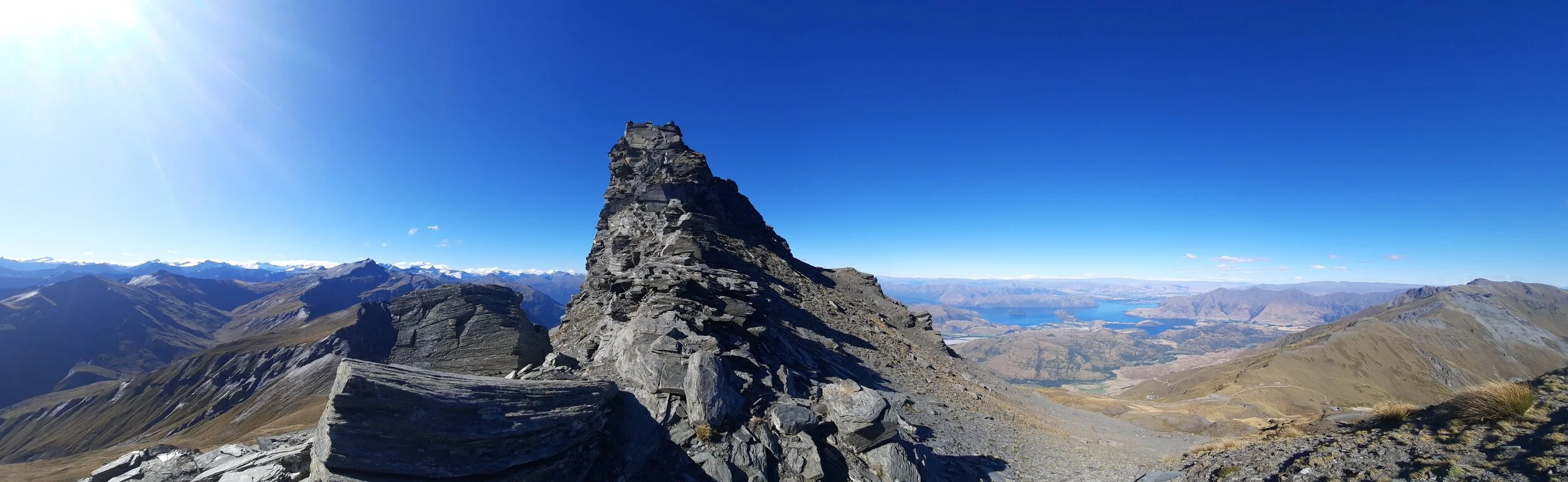
Afternoon panorama from Treble Cone summit. Black Peak at center left. End Peak at far right.


Summit panorama, with southwest in the center.
Summit panorama.
Hunting
Public land extends as far as the saddle between Point 1698 and Point 1826. Hunting is prohibited on this area of public land.
After this saddle, it’s The Branches Station land all the way to the summit. Calling for permission to cross (034418421) also means you would learn if they are culling any pests.
Public land on which hunting is generally allowed begins at the summit, so this is mostly relevant to anyone continuing past the summit, e.g. on a multi-day hike to Fog Peak and West Matukituki Valley.
How many Black Peaks are there?
During my hike, I found a lost iPhone near the summit, so I took it to the police station for lost & found. When I told the officer on duty that I had found it at Black Peak, she asked which one I meant: the mountain or the Wānaka eatery, Black Peak Gelato.
Nor should Black Peak be confused with the other two Black Peaks in Otago, although neither of them are quite as close as that ice cream shop. I previously hiked another one (1989m) from the village of Glenorchy on Lake Wakatipu, crossing the slopes of Mt McIntosh to get there. It wasn’t as much fun as this hike was. The third is an obscure peak on Mt Earnslaw, also near Glenorchy.
Nor should it be confused with Black Hill or Black Mountain in Canterbury, both of which are also hiking destinations.
Other pages about this hike
Pages about other routes to Black Peak
https://www.wildernessmag.co.nz/trip/black-peak-mt-aspiring-national-park/ (no longer permitted)
https://aspiringguides.com/trips/ski/black-peak-ski-snowboard-tour (via helicopter to private Black Peak Hut)
Nearby hikes
https://www.theoutbound.com/new-zealand/hiking/hike-to-the-summit-of-treble-cone (but not quite to the summit)
Nearby hikes further north, in the Matukituki Valleys
https://www.theoutbound.com/new-zealand/backpacking/climb-the-buchanan-peaks-above-lake-wanaka
https://neilsloan.smugmug.com/New-Zealand-/Wanaka-Hawea-/Fog-Peak-Niger-Peak/i-WTqV4zs
https://leeburty.com/leeburty/2014/10/25/fog-peak-mount-aspiring-national-park-weekend-fun
Hikes across the lakes
Black Peak seen from elsewhere


Above a large snowfield, it’s the mostly black peak which is central at 0:02. Seen from Roy’s Peak lookout.