Pouakai Summit & Tarn, New Plymouth, NZ


I started at the top. At the fork, I first took the shorter leg east, then the longer leg west.
Screenshots of the NZ topographic map are licensed as CC BY 4.0 by Toitū Te Whenua Land Information New Zealand (LINZ).
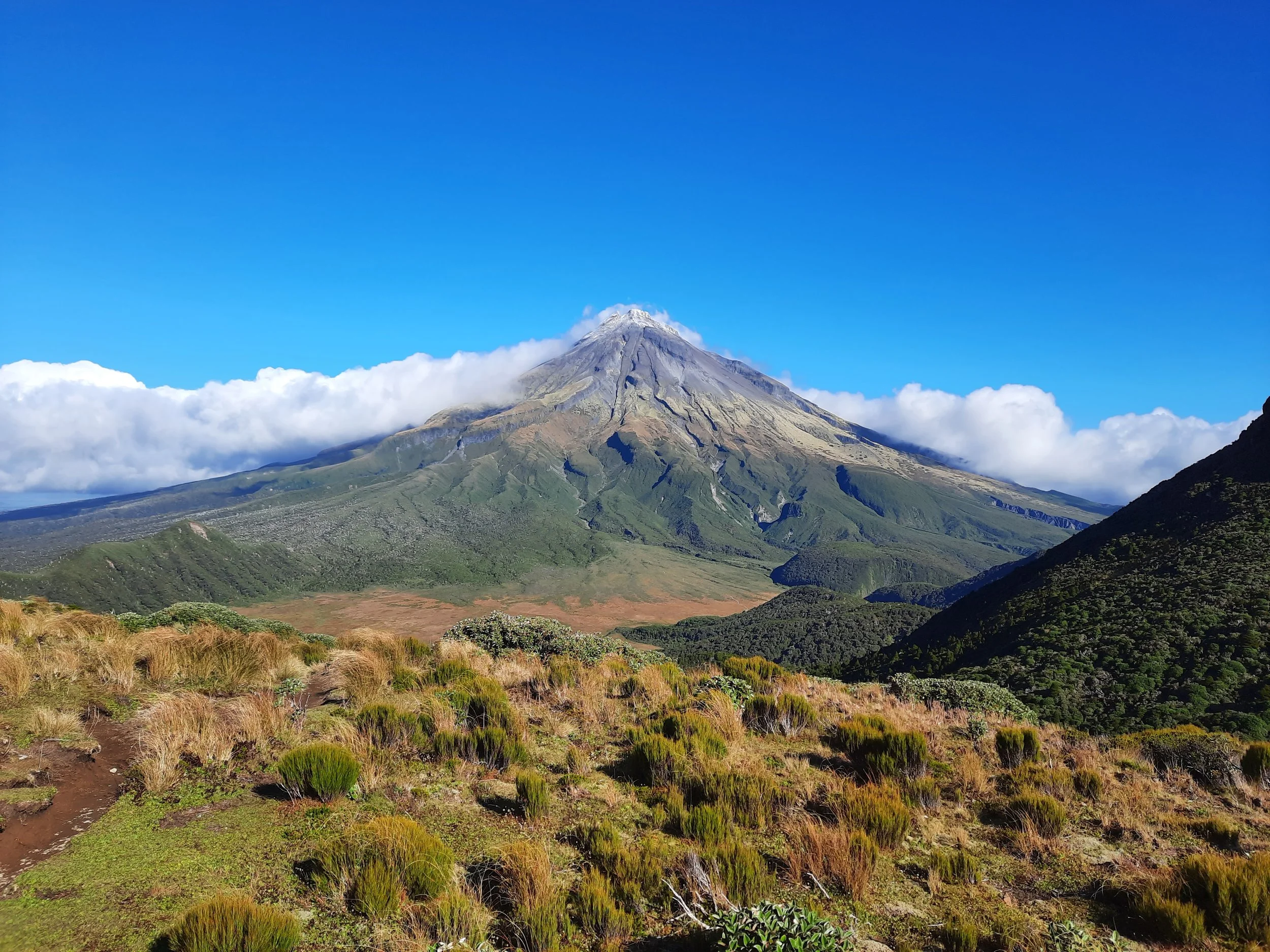
The Pouakai Range lies between New Plymouth and Mt Taranaki, in the Taranaki region of western North Island. Pouakai summit (Pouakai Trig, 1400m) is the highest point in the range. I reached it via the Mangorei Track, from Mangorei trailhead, and then Pouakai Track. Mangorei trailhead is 25 minutes from New Plymouth.
I also visited a tarn, famous for its photo opportunity of Mt Taranaki, in the other direction along Pouakai Track.
Access
Mangorei trailhead is mostly used as a starting point for day-hikes to Pouakai Hut and the nearby tarn; as one end of the point-to-point day-hike Pouakai Crossing; or as one of the two easiest access points to the multi-day Pouakai Circuit. North Egmont is the other end of the Crossing, and the other easy access point to the circuit.
The trailhead has a toilet and a very large parking lot. It was nearly full when I arrived on the afternoon of Easter Saturday, around three hours after arriving at New Plymouth airport from Auckland.
Time
Including breaks, it took me around 7 hours 10 minutes to reach the tarn and Pouakai Peak before returning the way I came.
Route
AllTrails reports that the out-and-back hike to Pouakai Summit gains 963m over 15.4km return. By adding in the visit to the tarn, I probably added around 50 metres and 2km to those numbers.
From Mangorei trailhead, the track enters the forest. It is a mixture of well-graded gravel, wooden boardwalk with rubber on it, slippery tree roots, dog-sized rocks, and puddles. The main problem is that it is narrow, so hikers have to take care when passing each other. I would aim for a weekday, rather than a weekend, to avoid this.
The track emerges from the forest not far below Pouakai Hut. After resting in the hut, I continued uphill to a T-intersection. First I went left (east), to the famous tarn. It was a windy day, so I didn’t get a clear reflection of Mt Taranaki. Then I returned to the T-intersection and went the other direction (west).
The trail was good so long as it was part of Pouakai Circuit (heading toward Holly Hut). It became awful at the turnoff to Pouakai summit: a rising series of mud steps (held in place by vertical wooden panels), each of which was basically a puddle. I gave up and turned around, but seconds later another hiker descended the steps. He assured me the wet part would only continue for a few minutes, and he didn’t have the gaiters which I was wearing. So I gave up on giving up, skirted the puddles to the extent possibly, and escaped the waterlogged part of the track near the point where the track comes closest to Tatangi Peak.
From there, it was an easy undulating walk to the base of Pouakai summit, with the occasional pole marking the fairly obvious path. On the summit hill, it was a steep climb on a somewhat loose dirt slope, which was deeply channeled in places. At some point the walls of these channels will cave in, as there is no rock holding them in place. Presumably after heavy rain. I appreciated my trekking poles while descending this.
The summit is marked by a trig, which I used to block out the sun so I could take a photograph to the west.
Night fell when I was not far past Pouakai Hut on the way down, so I returned to the parking lot with the help of my headlamp. The 200+ people I passed earlier had been reduced to a single couple also returning to the parking lot, so it was an exceedingly peaceful forest walk once I passed them.
If 1 is an easy track, and 4 is using hands and feet on exposed rocks, I give this hike a 3 at worst.


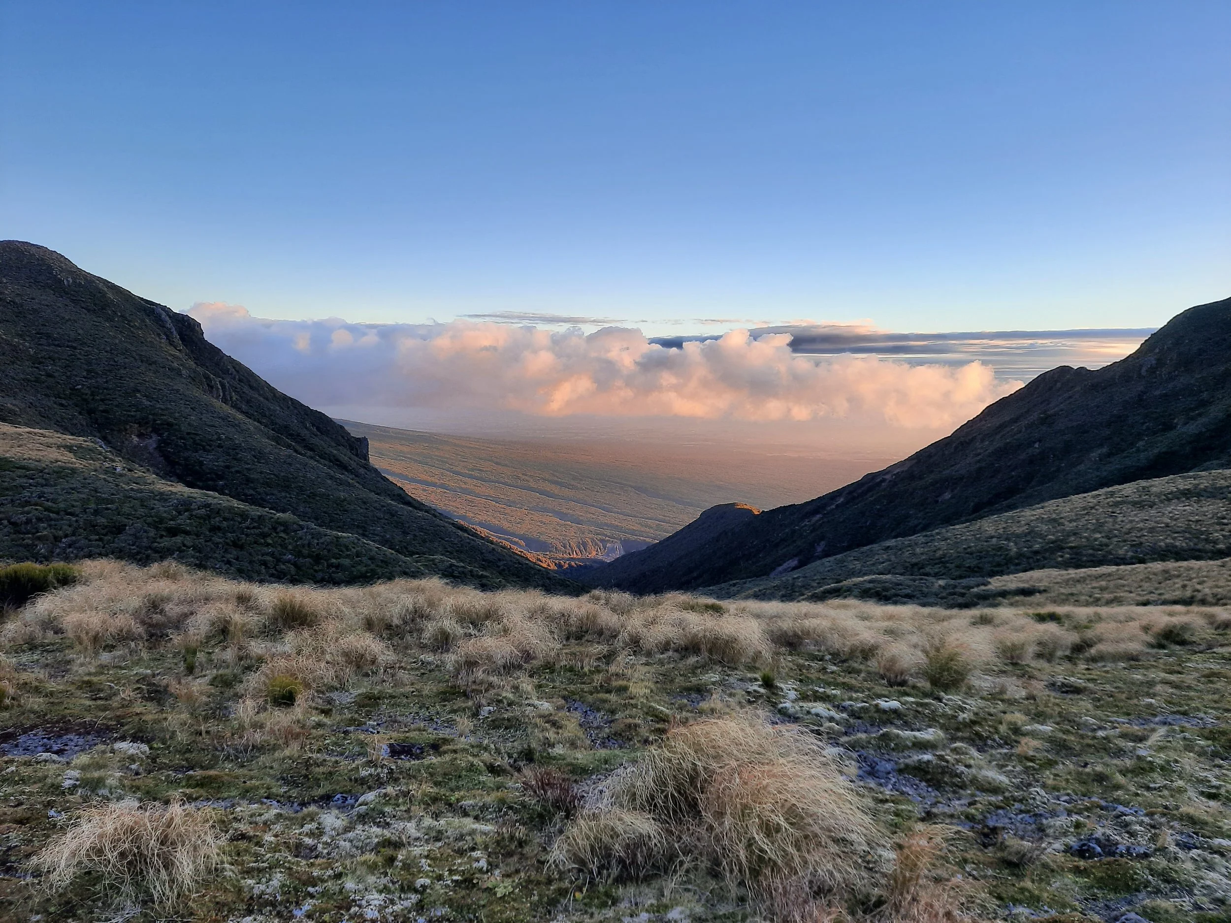


Panorama from Pouakai summit.
Hunting
Nearly the entire route is in a hunting area (for goats and possums). Hunters are forbidden to “discharge firearms near tracks, huts, campsites, road-ends or any other public place.” I have hiked in more than 30 hunting areas, and only passed hunters twice - this wasn’t one of those hikes.
Here is the DOC topomap with all hunting areas visible.
Other pages about the two portions of this hike
https://www.alltrails.com/trail/new-zealand/taranaki/pouakai-summit-track
https://www.nznatureguy.com/2020/01/02/pouakai-summit-taranaki/
https://planmywalk.nz/tracks/mangorei-track-to-pouakai-tarns
Other hikes to Pouakai summit
https://www.wildernessmag.co.nz/trip/pouakai-via-dover-route-egmont-national-park/ (GPX)
https://www.nznatureguy.com/2020/04/08/pouakai-trig-dover-track-day-hike/
Pages about other Pouakai Range hikes
https://www.nznatureguy.com/2019/01/12/henrys-peak-taranaki-egmont-national-park/
https://www.meghanmaloneyphotography.co.nz/post/hiking-the-pouakai-circuit-taranaki-premier-multi-day-hike (helpful 3D map of the area)
Not sure what’s going on with DOC’s URLs. Hopefully they’re transitioning to the short version.

