St Arnaud Range Track, Nelson Lakes, NZ


Nelson Lakes. The St Arnaud Range Track is unlabeled in the upper right corner.
Screenshots of the NZ topographic map are licensed as CC BY 4.0 by Toitū Te Whenua Land Information New Zealand (LINZ).
The St Arnaud Range Track is a medium-length hike which ascends into the St Arnaud Range from the village of St Arnaud, Nelson Lakes, Tasman Region South Island.
The St Arnaud Range rises on the east side of Lake Rotoiti, which is one of the two Nelson Lakes. Across the lake is Robert Ridge, along which I did the better-known hike to Lake Angelus. The St Arnaud Range Track hike was my way of gaining fitness for that much longer hike.

Screenshots of the NZ topographic map are licensed as CC BY 4.0 by Toitū Te Whenua Land Information New Zealand (LINZ).
Time
DOC estimates 5 hours return, not including my extension to Point 1787. Nelson Trails estimates 4-5 hours for the same.
I hiked from the trailhead to the ridge in around 2 hours 40 minutes, then rested. After that, I did a roughly 30-minute round-trip south along the ridge to Point 1787. Finally, I hiked down in around 2 hours 30 minutes.
Route
AllTrails reports that the hike to the ridge alone gains 1068 meters over 10.8 kilometers, out and back.
The trailhead starts from Kerr Bay campsite, on the eastern margin of St Arnaud village and the shore of Lake Rotoiti. I worried about sandflies, but after applying the Okarito (citronella) repellent sold at DOC offices, I wasn’t bitten by any. Other insects (not sandflies) buzzed intensely as I began ascending through the forest.
Signposts made clear which turn was for the loop walk and which turn was toward the ridge.
About 40 minutes after I started, and past the loop track, I took a wrong turn along a trapline. A trapline is a series of traps for predators, set out in a line, with route indicators to help humans spot where the line is going. I think this trapline’s indicators were blue. I called DOC to verify I was not supposed to be following these wrong-color indicators, and made my way back to the proper track, which probably had the normal orange indicators. Treefall may have contributed to my wrong turn.
I couldn't spot the Parachute Rocks, labeled on the map. I assumed they were parachute-shaped, analogous to how the Punakaiki Pancake Rocks on the West Coast of South Island are pancake-shaped. It turns out that I stood on the Parachute Rocks, which are not parachute-shaped. They are named for the parachutists who sometimes parachute from them, but I didn't make the connection due to the absence of parachutists.
After those two embarrassing errors, it was an uneventful hike to the ridge. An easily visible impact track led south, so I took it as far as Point 1787. The next most prominent point was around 2.5 kilometers further south, so Point 1787 was a suitable turnaround point. If this hadn’t been my first hike of my trip, I probably would’ve continued further south. I also might have explored the tarns.
The Christchurch Tramping Club continued much further south than Point 1787 as part of a 2-night trip. Click here for their route.
If 1 is an easy track, and 4 is using hands and feet on exposed rocks, I give this track a 3 on a few brief spots, but overwhelmingly a 1 (especially the lower forest) and a 2 (much of the rest).


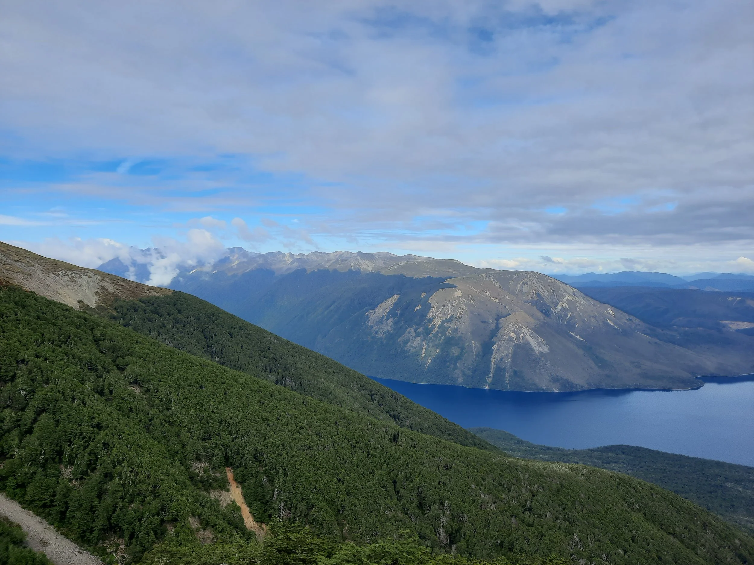
Robert Ridge at left, across Lake Rotoiti. St Arnaud at center-right, separated from the shore by woods.

Looking south. Raglan Range at left. Robert Ridge at center-right. St Arnaud at right.
Hunting
A hunting area begins just beyond the ridge that the track ascends to. Hunters are forbidden to “discharge firearms near tracks, huts, campsites, road-ends or any other public place.” I have hiked in more than 30 hunting areas, and only passed hunters twice - this wasn’t one of those hikes.
Here is the DOC topomap with all hunting areas visible.
Other pages about this hike
https://www.alltrails.com/trail/new-zealand/nelson-tasman/saint-arnaud-range-track
https://www.wildernessmag.co.nz/trip/st-arnaud-range-track-nelson-lakes-national-park/ (GPX)
https://www.theoutbound.com/new-zealand/hiking/hike-the-st-arnaud-track-in-nelson-lakes-np (precisely my route - to Point 1787)
Other day-hikes that went further
over the ridge to the tarns: https://www.wildernessmag.co.nz/trip/st-arnaud-range-tarns/ (GPX)
Multi-day hikes
General Nelson Lakes pages
The St Arnaud Range seen from Tophouse

St Arnaud Range at left. Robert Ridge center-right. Big Bush Forest hills far right.
The St Arnaud Range seen from Robert Ridge, across Lake Rotoiti

St Arnaud Range at right. I think that Point 1787 is the high point visible on the ridge. If so, then I must have ascended the spur which is two spurs north (left) of that high point’s spur. In other words, I think that I ascended the spur just left of the large, light gray spot.
Richmond Range in central distance.