Double Peak, Lindis Pass, NZ
Double Peak (1323m) is a hill rising above South Island’s Lindis Pass. I went on a short hike there. The pass separates Canterbury’s Mackenzie Basin from the Lindis-Tarras area of Central Otago. Most hikers do it as an out-and-back, but I did it as a circuit to avoid a steep descent through snow. Even without snow, I probably would have chosen the circuit.
Don’t confuse Lindis Pass with Lindis Peak, a mountain further south in Central Otago.
Scroll down to the bottom of this page for photos without snow.
Time
One AllTrails user reports that the hike took 1 hour up and 30 minutes back to the parking lot. Edward at HikingScenery also reported around 1 hour 30 minutes total. These times are for out-and-back.
My hike was a longer circuit. Uncharacteristically, I recorded my time with an app. I spent about 1 hour 40 minutes moving. My whole circuit was around 3 hours 50 minutes. I must have spent a lot of time taking photos and enjoying the views.
Route

Screenshots of the NZ topographic map are licensed as CC BY 4.0 by Toitū Te Whenua Land Information New Zealand (LINZ).
My route was 4.2 kilometers, with 392 meters of elevation gain, according to my AllTrails recording.
The medium-sized Lindis Pass parking lot is just on the Canterbury side of the border with Otago. It is the cyan dot on my topomap screenshot. The parking lot had a regular flow of drivers stopping to take photos and enjoy the scenery.
From there, I walked west for a few minutes along a gentle incline, then set off directly uphill for the nearer (lower) peak of Double Peak. The ascent was steep, but there was tussock to grip through the snow.
The snow’s consistency seemed the opposite of avalanche-prone. Also, it was just 5-30cm deep on the windward slopes. But wind-loading had made it deeper on the leeward slopes. So I didn’t step on that snow.
From the lower peak, I walked southwest along the short ridge to the higher peak.
After returning to the lower peak, I decided to make a circuit. I followed cross-country ski tracks north down a spur.
Eventually I came to a shallow gully where I ran downhill through shin-deep soft snow to the roadside. From there, I walked uphill to the parking lot for several minutes. Breathing in the exhaust of the big trucks struggling up toward the pass was unpleasant.
If 1 is an easy track, and 4 is using hands and feet on exposed rocks, I give the ascent a 3 in the snow I encountered, and imagine it would be a 2 without snow. I give the descent a 2 in the snow I encountered, and imagine it would be the same without snow.


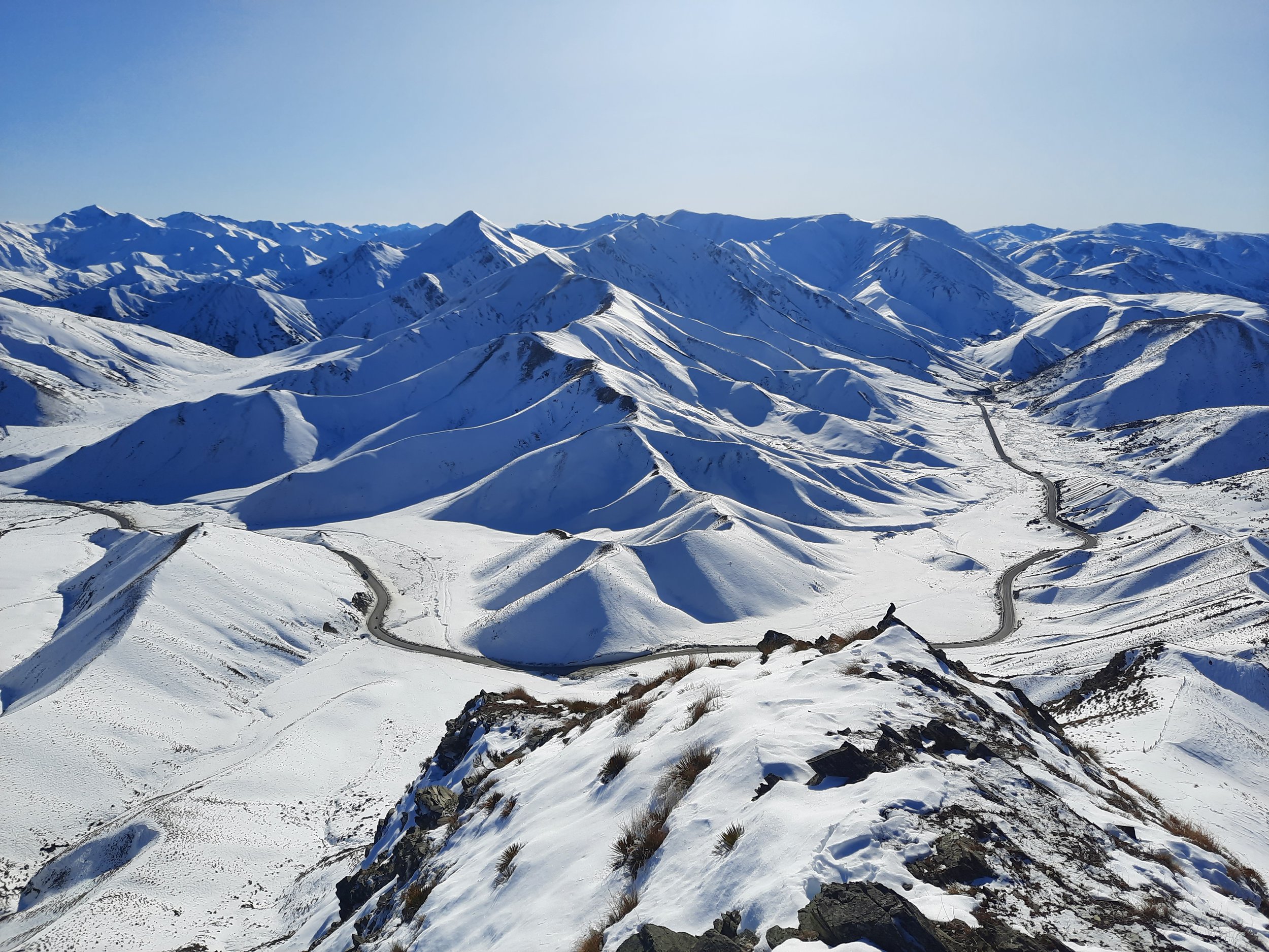
Central Otago to the left. Mackenzie Basin to the right. My ascent route is obscured by the peak. My descent route is at far right.
Note some sort of bird on the ground at right. What species would perch up here? What might it be eating?
Other hikes (out-and-back) to Double Peak
almost straight from the parking lot
ascending a little further east, then turning: https://hikingscenery.com/double-peak-lindis-pass/
Routes around the back (east) of Double Peak
Come and explore the new eastern part of the Lindis Pass Scenic Reserve. Easy walk up a headwater branch of Longslip Creek on 4WD track to the Morven Hills Pylon Track at the head of Dip Creek. View sag ponds on the Longslip Fault line. Return via track or climb the Double Peak ridge and go back that way.
The Lindis Pass Conservation Group is most likely referring to this trailhead beside the highway just northeast of the pass, which was within view from my hike. Based on the group name, they sound like a good group of people to ask for advice on hiking in the vicinity.
Continuing on from that is the long Pylon Track to Goodger Road: https://www.doc.govt.nz/contentassets/6349fa05af854e2eaeeefa0f83b7db8d/lindis-pass-tracks-brochure.pdf. The brochure also includes other tracks in that area.
Nearby hikes
Sealy Tarns, Mt Cook village


