Mt Shrimpton, Makarora, NZ


The formed track ends at the bushline (the obvious elbow shape, between green forest and orange open terrain).
Screenshots of the NZ topographic map are licensed as CC BY 4.0 by Toitū Te Whenua Land Information New Zealand (LINZ).
Mt Shrimpton is a mountain next to the village of Makarora in the remote north of the Queenstown Lakes Region of Otago, South Island, New Zealand. In a very long day-hike, I ascended Mt Shrimpton Track up a spur to the bushline, next followed an impact track up the spur’s ridge until I lost it, then ascended through tussock and shrubs to a ridge at around 1920m elevation. The ridge is between the summit of Mt Shrimpton and Point 1960 to its southwest.
The trailhead is on the edge of Makarora, 55 minutes by car from Wānaka.
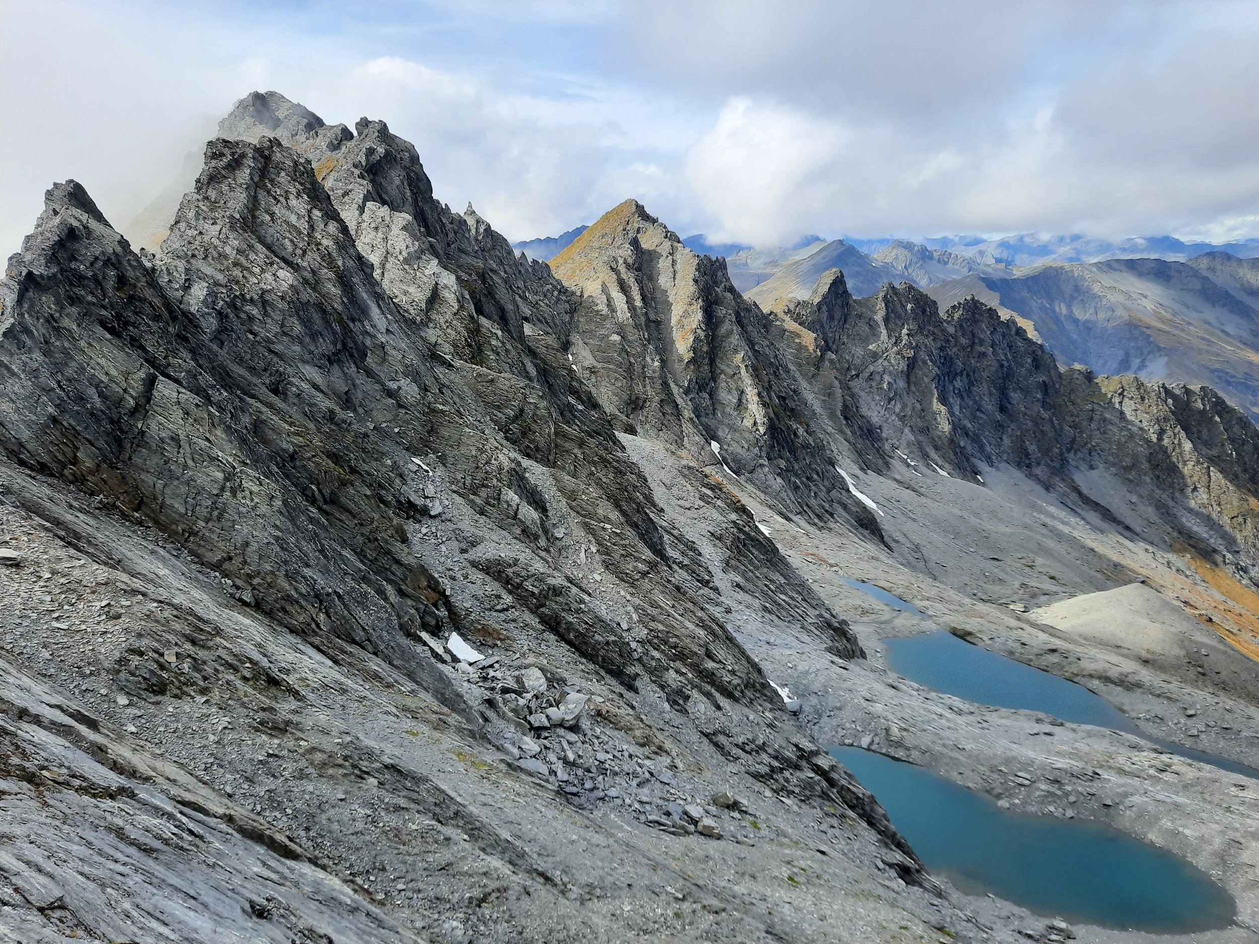
Reaching any point on the ridge is suitable for the impressive view of the tarns in the rocky basin beyond.
Time
My hike took around 11 hours, including all breaks. Excluding my long break at the ridge but including all other breaks, these were the components:
ascent 6 hours
2 hours 45 minutes to bushline
3 hours 15 minutes from bushline to ridge
descent 4 hours 10 minutes
1 hours 45 minutes from ridge to bushline
2 hours 25 minutes from bushline to trailhead (partly after dark)
Edward reports 8-9 hours return. DOC estimates 5 hours return to the bushline alone, similar to my 5h10.
Route
Different bloggers give different estimates of length and elevation gain. Part of this must be explained by different endpoints.
Jub has seen Strava hike recordings with around 1800m elevation gain - maybe these were to the summit
Edward says 10km return to the ridge over 1592m elevation gain
AllTrails says 10.6km over 1567m
commenter Najate Rabhi says 11.5km over 1685m or more in elevation gain
Almost all of the elevation gain is outbound.
Google Maps currently makes it appear as if there are two trailheads. But I only found one place to park, a small clearing at the southern of the two shown on that map. It is here. There was space for 5-8 vehicles.
I began my hike on the easy Mt Shrimpton Nature Trail, before diverging left for a rougher marked track that ascends steeply through beech forest. The ascent is monotonous, apart from the sound of Pipson Creek to the left at low elevations.
Part-way up, I found a pair of hiking boots, tied dangling on a leafless stump of beech tree. If this were a horror movie I would’ve eventually found out why the boots had been abandoned hundreds of meters above the trailhead. Alas, reader, it is up to you to supply the explanation.
Eventually I reached the bushline, where beech forest gives way to tussock. I cached a Powerade bottle in the tussock, to drink on my descent. The route also turns sharply left here. After this, there are no more orange markers, but an impact track follows the ridgeline. As or after the slope steepened, I lost the bushline. Ascending this was monotonous.
As I climbed toward the ridge, I heard the occasional small songbird, and stepped over a number of Mecodema black ground beetles. The annual stag roar (hunt) was on in the valley below, so the main sound I heard apart from wind was hunters imitating the stags’ roaring noises with some sort of horn.
It is possible to diverge left from the ridge and reach the summit. My hike was a few weeks after the autumn solstice, so I didn’t have enough daylight. Indeed, night fell before I finished my descent.
The very top of the ascent ridge is a prominent rocky pyramid, not marked on the topomap. I began climbing it, but decided it would be hard to ascend and harder to descend, so I turned back several meters and diverged right (south) to reach the flat ridge just south of it. North of the pyramid was the summit, and south of me at the far end of the ridge was Point 1960. (This Point 1960 is not to be confused with the other Point 1960 on the map, due east of the summit.)
Only a rock-climber could get from my ridge north to the summit. Just getting past the pyramid would be hard, and it looked harder beyond that.
Once on the ridge, I could see the rocky basin beyond, and its blue tarns. I couldn’t see any streams coming from the tarns. If there were any, they flowed down from the rocky basin into the wide valley of the High Burn, beyond which rose the Young Range. This was on the best views I’ve had in New Zealand. It was more similar to Arthur’s Pass scenery, especially the views on the Mt Cassidy - Blimit - Temple Col traverse, than to other hikes I’ve done in Otago. But behind me, the vast tussock slope was more like Otago and the lower mountains of the Mackenzie Basin.
A noisy gyrocopter flew over the basin, from east to west. I gave it a wave, and it rapidly changed its route to the north, to fly right over me. I’ve never been in a helicopter, so this was my only interaction with one.
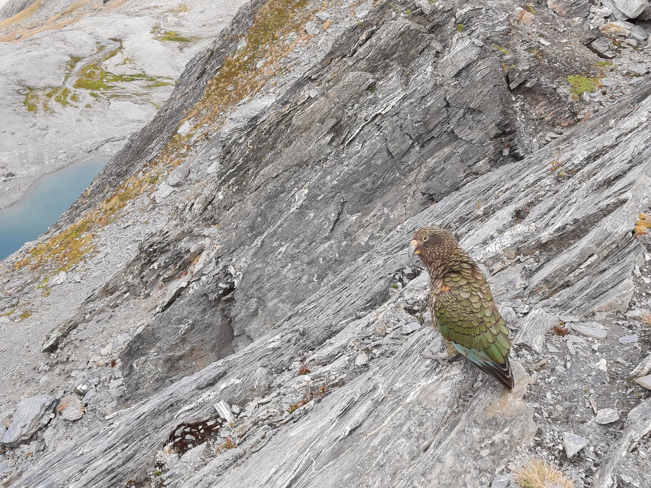
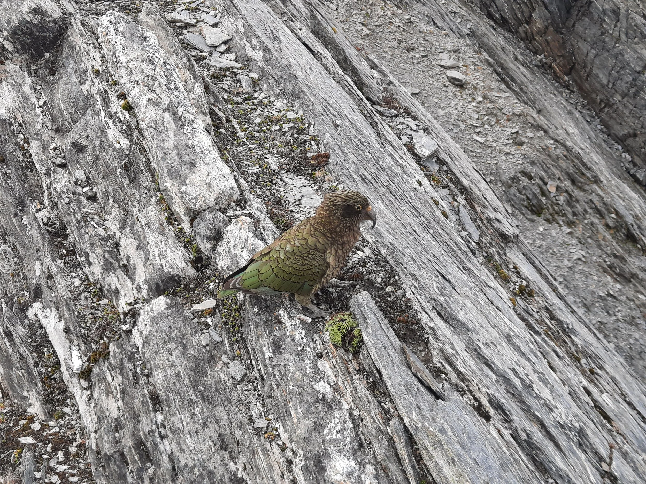
After the gyrocopter departed the area, a kea, then another kea, and eventually a total of nine joined me, flying to rest on either side of me on the ridge. I had never seen more than 3-4 on one hike before. The boldest keas hopped to within a few meters of me.
As I began my descent, the keas followed me for the first 100-200 meters. I am almost confident that I was finally able to get a photo pointing toward all of them, although I have never been able to spot the 9th kea in it. This was the only good thing I have to say about the descent, which was otherwise steep and unpleasant. Nevertheless, it was much faster than the ascent.
If 1 is an easy track, and 4 is using hands and feet on exposed rocks, then this hike is 3 at its worst. (It would be a 4 if one were to descend to the tarns in the basin beyond the ridge.)
There’s a second gallery with the kea photos, below the first one starting here:


The keas


Panorama from part-way up.
I didn’t realize it would fly over to me when me I gave it a wave. Next time I won’t wave, because sudden changes in helicopter direction probably increase the risk of stalling.
The first kea arrives.
The call of the kea.
Panorama with a kea call.
A kea trills as several of them follow me down the slope.
Hunting
The entire route is in a hunting area. Hunters are forbidden to “discharge firearms near tracks, huts, campsites, road-ends or any other public place.” I have hiked in more than 30 hunting areas, and only passed hunters three times - this wasn’t one of those hikes.
Here is the DOC topomap with all hunting areas visible.
Other pages about this hike, or turning back part-way up
Pages about hiking to the tarns or to the summit
https://churnewzealand.com/mount-shrimpton-track-summit/ (includes GPX file)
Pages about other hikes on Mt Shrimpton or in the High Burn Valley
multi-day traverse ending with Mt Shrimpton: https://www.southernalpsphotography.com/Tramping/Haast-Pass-to-Mt-Cook/High-Burn-Mount-Shrimpton
labeled peaks, and closer view of the High Burn than in my photos: https://www.southernalpsphotography.com/Tramping/Haast-Pass-to-Mt-Cook/High-Burn-Mount-Shrimpton/i-HgF9b33/A
how Danilo Hegg ascended to the summit: https://www.southernalpsphotography.com/Tramping/Haast-Pass-to-Mt-Cook/High-Burn-Mount-Shrimpton/i-CnpnSZ4/A
Mt Patriarch multi-day hike: https://neilsloan.smugmug.com/New-Zealand-/Wanaka-Climbs-Paddles-Bikes/Mt-Patriarch-11-13-November-2024
closer view of the High Burn than in my photos: https://neilsloan.smugmug.com/New-Zealand-/Wanaka-Climbs-Paddles-Bikes/Mt-Patriarch-11-13-November-2024/i-sbgZGkb/A