Isthmus Peak, Lake Hāwea, NZ


The Neck is a long north-south isthmus separating Lake Wānaka (left/west) and Lake Hāwea (right/east) in Otago, South Island. Isthmus Peak (1386m) is a long hike on the Neck, about 20 minutes north of Hāwea township on Makarora - Lake Hāwea Road.
DOC reports that the track is closed for fawning (i.e. baby deer time) between 20 November and 20 December. This is later than the lambing closure dates on numerous other Queenstown Lakes region and Central Otago tracks. Isthmus Peak is therefore an option for people who visit Wānaka in lambing season and can’t hike Roy’s Peak.

Screenshots of the NZ topographic map are licensed as CC BY 4.0 by Toitū Te Whenua Land Information New Zealand (LINZ).
Time
DOC says that ascending to the peak takes 3-4 hours and that the return trip takes 5-7 hours.
AllTrails users reported an average of 6 hours 40 minutes.
Including breaks, it took me around 8 hours.
Route
Stuck stag. As mentioned, I phoned the hunting lodge to get it some assistance. In the days before mobile internet, I wouldn’t have known who to call; and then there were days before mobile phones, too. The 2020s are a fine time for this sort of antler mishap.
Someday I may learn how to rotate every frame in a video by a few degrees.
Round-trip, AllTrails reports an elevation gain of 1121 meters and a length of 15.6 kilometers.
There are two parking lots on the right/east (lakeside) of the highway. Google Maps labels them as Isthmus Peak Track Parking (closer to Hāwea township) and Isthmus Peak Trail Small Parking (further north). I used the southern one, which has more space.
The hike begins in a forest with open patches, but soon becomes open terrain.
Beside the track, a stag had got its antlers stuck in a fence. I called the hunting lodge and asked them to free it. The man I spoke with promised to do so, and it was gone when I came back downhill in the afternoon. (So either a lodge employee freed it alive, or a hunting tourist took a very easy trophy.)
The track was steep in a few places, but mostly easy. On the ridge, there is a fork:
The northern (right) track continues a short distance to the summit.
The southern (left) track goes on a long journey south along the ridge to Matatiaho Conservation Area. This public land connects downhill to Craig Burn parking lot on the highway, so a C-shaped through-hike is possible in principle. But there is no track. Based on the map, I wouldn’t try it.
If 1 is an easy track, and 4 is using hands and feet on exposed rocks, I give this a 2 at worst on the steep parts of the ascent track. The ridge track is a 1.


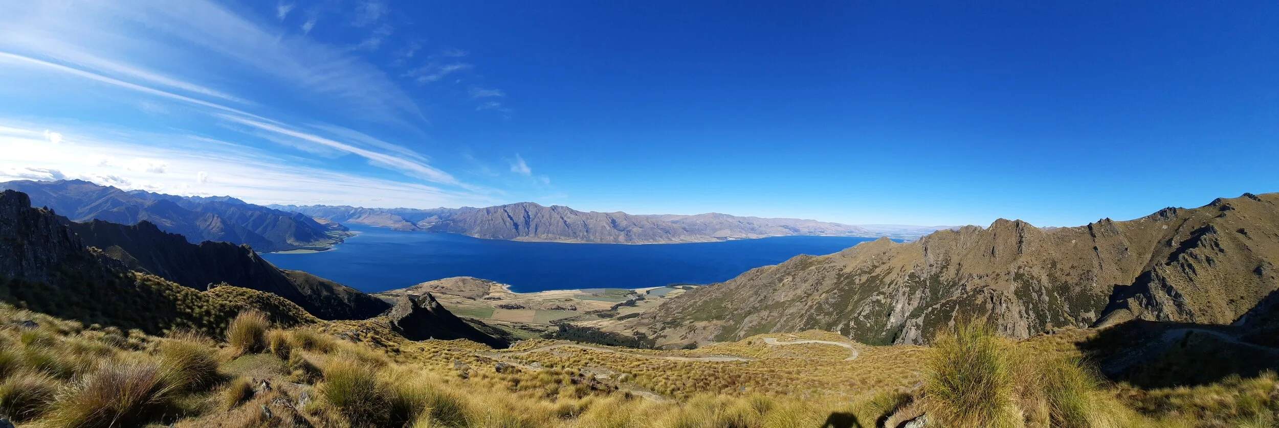
Lake Hāwea.
Sentinel Peak seems to be the highest peak at left. Sawyers Bush Track climbs the forested spur just left of the lowest lakeshore greenpatch, and then you can trace the Sentinel Peak route along/near the ridge to that high point. It was notably more difficult than this hike.
Corner Peak and, directly behind it (perhaps invisible) Dingle Peak, are the highest peaks in the center-left. Corner Peak was also notably more difficult than this hike.
Harder to spot, just right of center, is Breast Hill. It took a similar amount of time to this hike, but was much steeper, making it rather less pleasant. Just right of Breast Hill is the less prominent Breast Peak. It is even harder to distinguish from the ridge.

Lake Wānaka. Hidden at far left is the town of Wānaka. Difficult to spot at left is Roy’s Peak. In front of it is Mou Waho Island.
Mount Aspiring (Tititea) at center-right. The steepness of the peak led me to wonder if the words spire and aspire are related. They are not. Spire is of Germanic origin, while aspire is of Franco-Latin origin.
Hunting
The track is an easement through land owned by a deer-hunting lodge. DOC recommends extra caution during the hunting season from March to May - the stag roar (rut).
Hunters are forbidden to “discharge firearms near tracks, huts, campsites, road-ends or any other public place.” I have hiked in more than 30 hunting areas, and only passed hunters twice - this wasn’t one of those hikes.
Here is the DOC topomap with all hunting areas (except private ones, like this) visible.
Other pages about this hike
Matatiaho Conservation Area
Isthmus Peak seen from elsewhere


Did you believe me when I said that Isthmus Peak is on an isthmus? Seen from Sentinel Peak.
Lake Hāwea is on the left. Corner Peak is kind of at the corner, a bit shorter than Dingle Peak to its left. Breast Hill is barely visible to the right. Hāwea township and the agricultural land behind it (Hāwea Flat) are visible but faint at the far end of the lake. Wānaka is at the far end of the other lake, not really visible. Nor is Roy’s Peak properly identifiable. But at far right, Mt Aspiring’s snowcapped spire can be seen.