Mt Arthur - Horseshoe Basin circuit, Motueka, NZ


Mt Arthur (Tuao Wharepapa; 1795m) is a popular long hike in Kahurangi National Park’s Arthur Range. It is around 45 minutes from Motueka in the Tasman District of South Island. The mountain straddles the border between the Tasman and West Coast Districts.
The normal hike is a poled route out-and-back from Flora parking lot, almost all of it on a visible track. I ascended by this poled route, then descend an unmarked route around the northwestern side of Horseshoe Basin, before taking a portion of the Gordon’s Pyramid track back uphill to a T-intersection with the Mt Arthur track. (Gordon’s Pyramid is a smaller mountain nearby.)
This was one of my two favorite hikes in northern South Island. The other is the hike along Robert Ridge to Lake Angelus, which is in the Nelson Lakes area further south.
Mt Arthur should not be confused with Arthur’s Pass, a hiking region in Canterbury (further south), or various obscure Mt Arthurs elsewhere in NZ.
Time
DOC estimates that it takes 3.5-4.5 hours one-way to the summit.
Including all breaks, my entire circuit took around 8 hours 45 minutes. This included:
around 3 hours 10 minutes southwest from the parking lot to the summit, including breaks
long break at the summit
around 2 hours 10 minutes northeast from the summit, down the unmarked ridge-spur, including breaks
around 40 minutes east along the Gordon’s Pyramid track, back to the Mt Arthur track (no significant breaks)
around 1 hour 55 minutes back northeast to the parking lot (no significant breaks)
Route
AllTrails reports 970 meters of elevation gain over 17.1 km return. My route would be similar in length, based on looking at the map below. The scenery is great for a hike involving so little elevation gain! But there’s a catch: the drive to the trailhead.
The long uphill access road to Flora parking lot is in bad condition and sometimes steep. I wouldn’t do it without 4WD. Passing other cars would require backing up in some places. I got lucky by not needing to pass anyone. It’s shorter, but also more nerve-wracking due to the narrowness, than the rocky logging roads up to the Ben Nevis trailhead (further east in Tasman District).

Red is on track. Purple is my approximate descent route, untracked.
Screenshots of the NZ topographic map are licensed as CC BY 4.0 by Toitū Te Whenua Land Information New Zealand (LINZ).
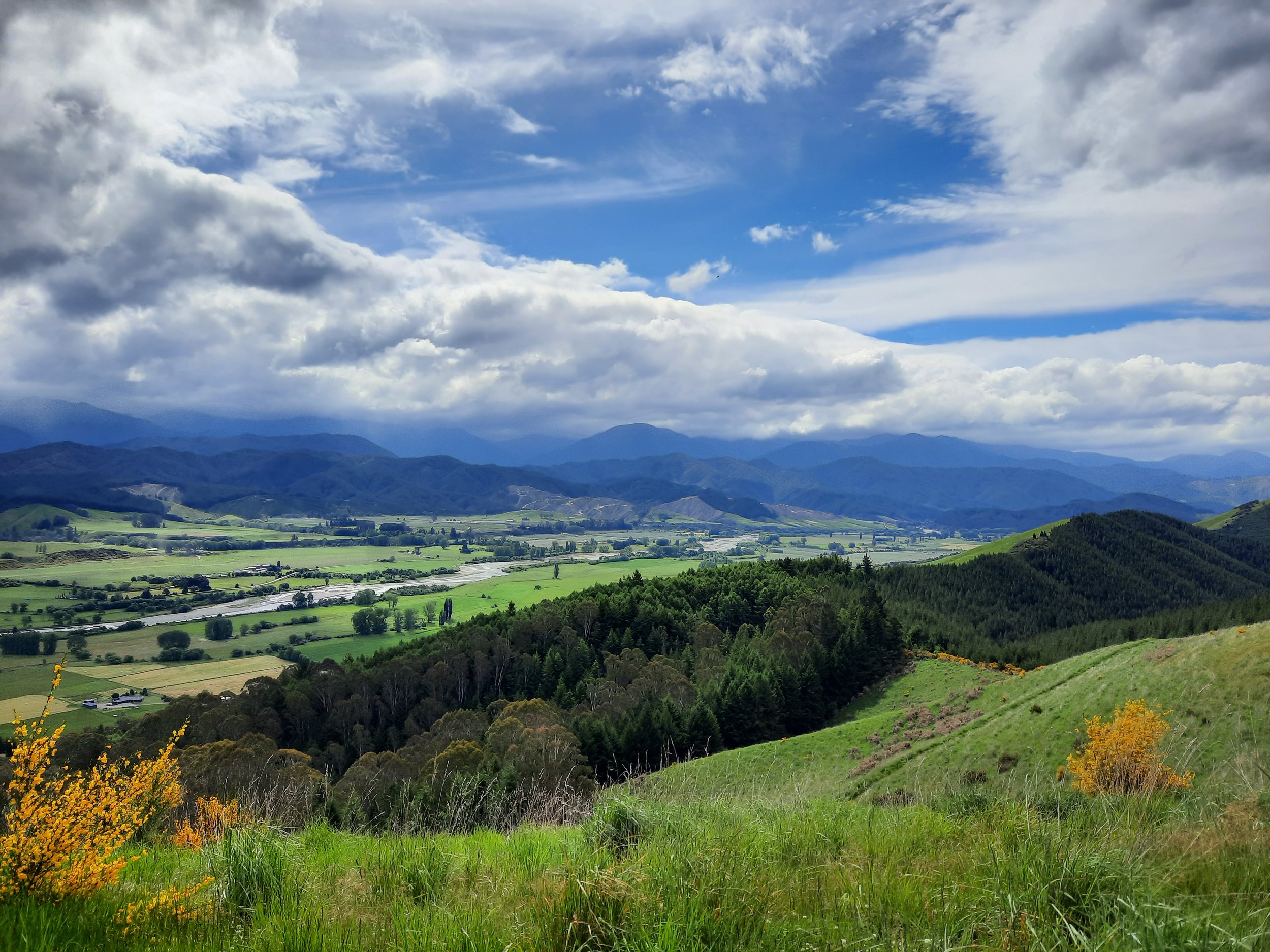
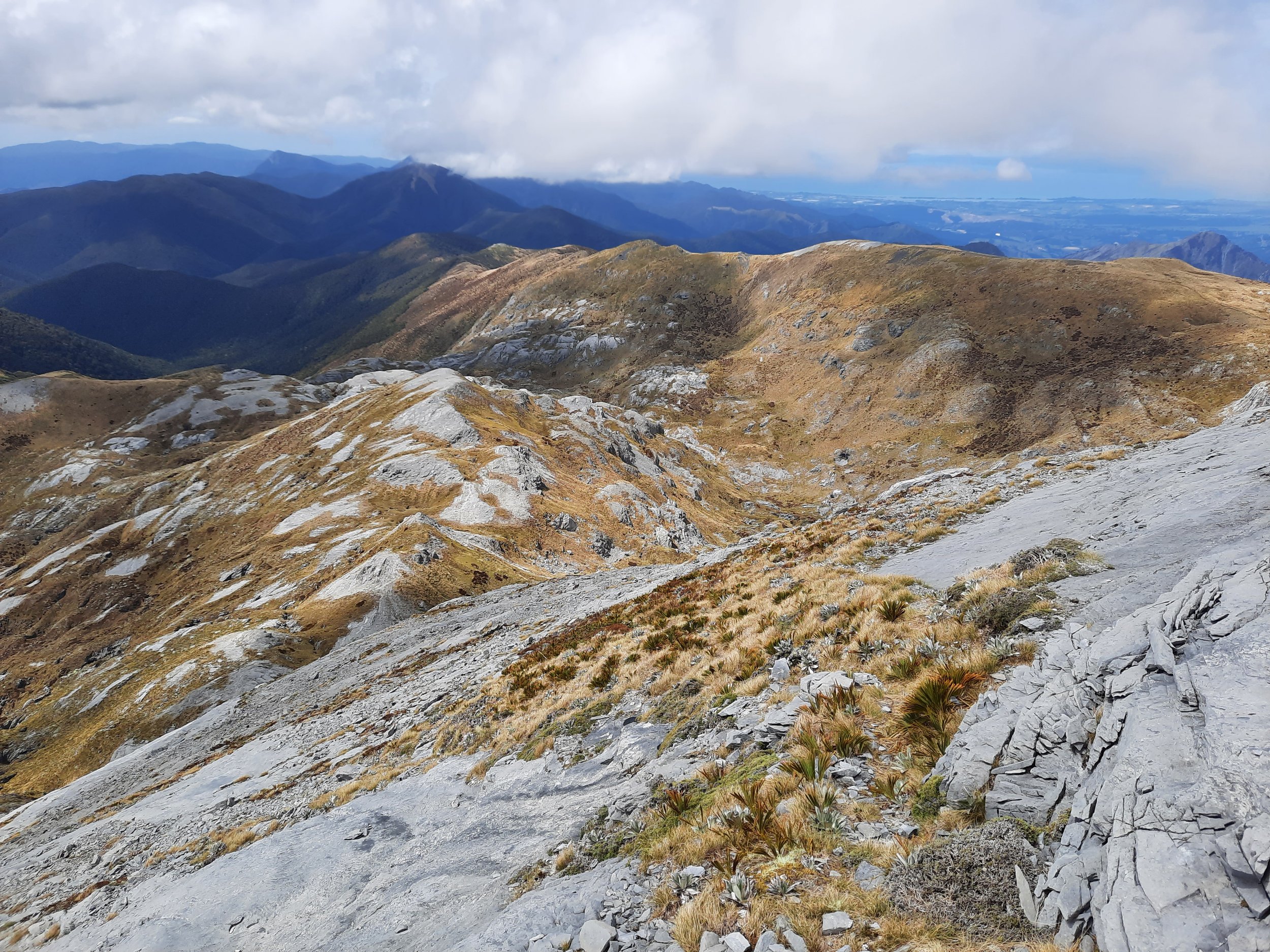
It gets much better after parking. The track is wide and in good condition as far as Mt Arthur Hut. This portion is entirely in pleasant forest, which thins out as elevation increases. After the hut, there is an impact track with poles for guidance. This track is sometimes rough as it continues through a little more forest and then along a tussocky ridge which forms the southeastern wall of Horseshoe Basin.
Approaching Winter Peak and Mt Arthur (which form the southwest of the basin), the track becomes rocky and sometimes disappears. There are blue poles for guidance. I had to use my hands to pull myself upwards in about ten places in the rocky final kilometer to the summit, but I wouldn’t call it strenuous.
The route does not go over Winter Peak’s summit, but getting there as an option didn’t look difficult.
As I was on my way to the summit, I offered a dollop of sunscreen to a very sunburned, hat-less returning hiker, who accepted it. It was too little, too late.
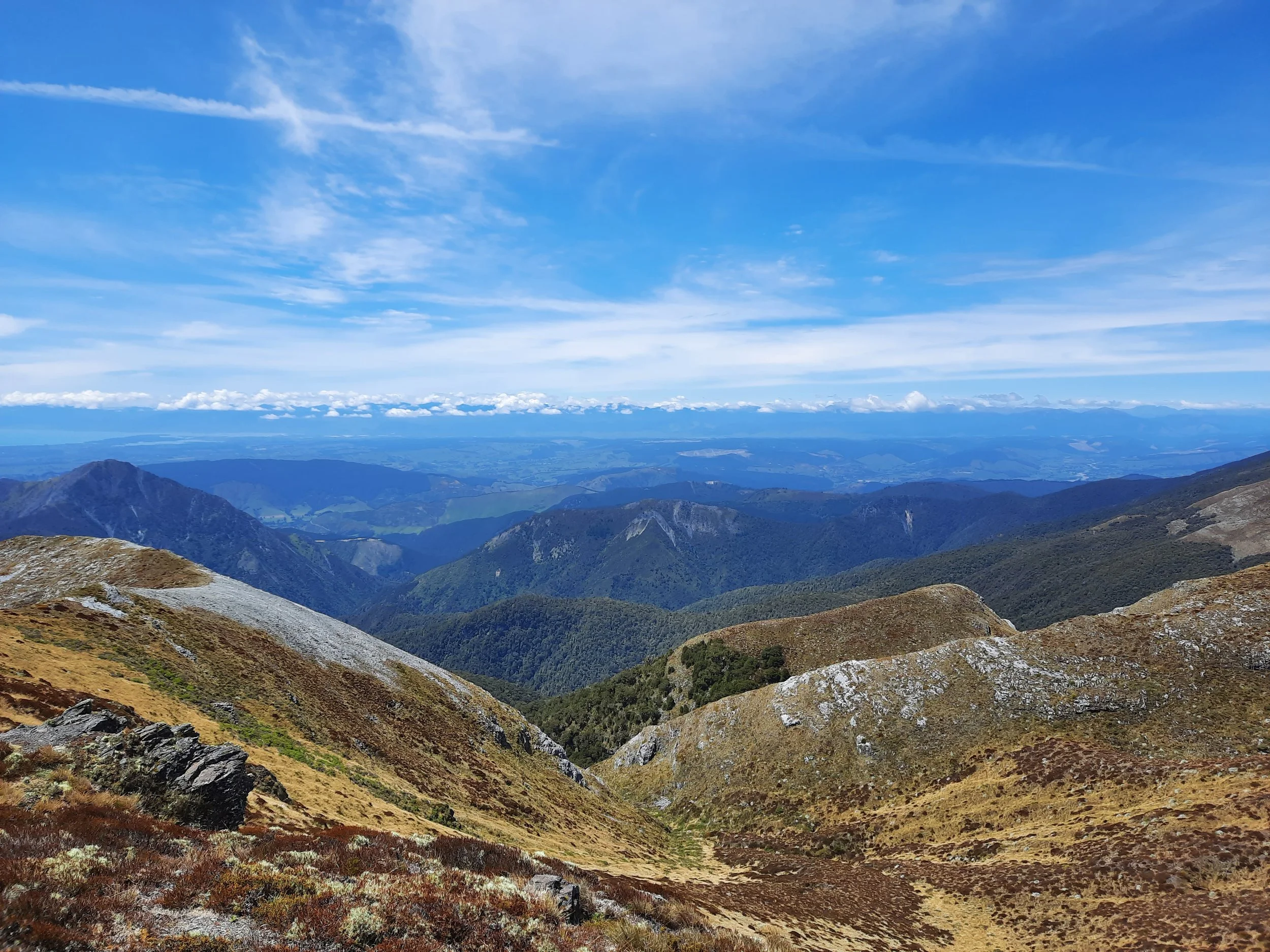
The summit plateau of Mt Arthur has good views in all directions. It has a crescent-shaped wind shelter in which I rested for a while. It wasn’t a fully effective wind shelter, but I enjoyed feeling and hearing the wind winding around the inner, supposedly sheltered part of the crescent.
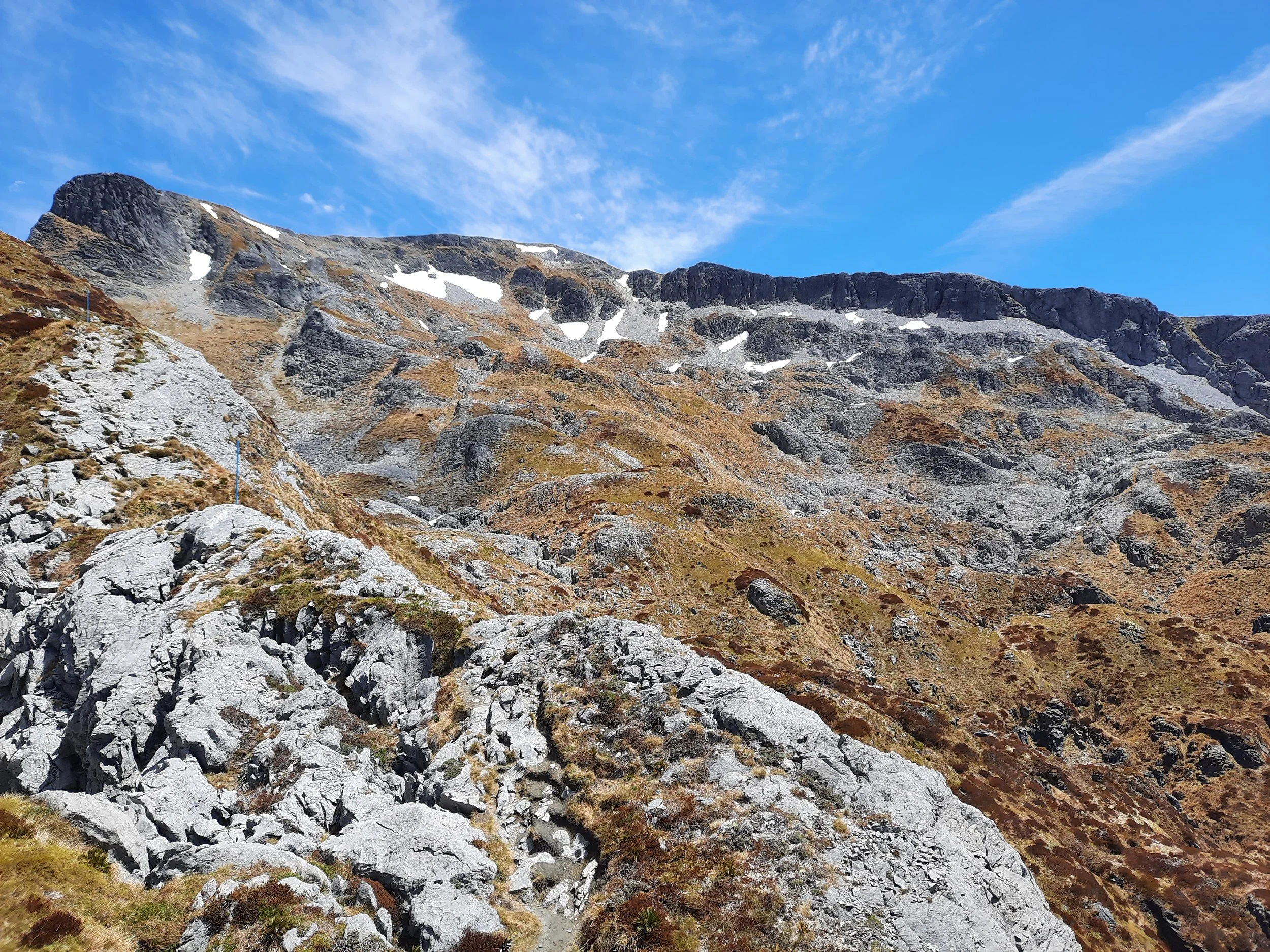
I observed two hikers going down the unmarked rocky ridge-spur on the west side of Horseshoe Basin, so I tried it myself. See the purple line on the topomap screenshot. It was quite narrow in two places (see a photo of one, below), so I used trekking poles to steady myself there in case of a gust of wind. Both of these places were close to the summit plateau.
A bigger problem was descending steeply, and not being sure where was best. The route forward/down was often not visible until I walked up to the edge of a prominent rock formation. A few cairns indicate helpful descent routes, sometimes along stretches of tussock which aren’t easily visible. These tussock stretches seemed more likely to be on the left, or outside, of the basin - which is not the direction a hiker ultimately aiming to the right might think to look. See photos 29 and 30, below, for an example.
Knowing what I know now, I would have ascended this ridge-spur to the summit of Mt Arthur, and then descended the easier, poled normal route with its impact track. Also, I would have worn gaiters, because of the speargrass on the unmarked portion.
The main advantage of descending this spur is that it is easier to see sinkholes. This area has karst topography, so there are a lot of these along the unmarked descent, as well as beside the poled tracks. “Smaller holes may be hidden by tussock, so don’t assume your next step will be on solid ground when travelling across this terrain.” (Peter Laurenson, 2023, Wilderness Magazine)
From the T-intersection with the track to Gordon’s Pyramid, it was a poled dirt impact track back uphill to the eastern spur. From there, I returned to Mt Arthur Hut and then the parking lot along the track which I had taken in the morning.
If 1 is an easy track, and 4 is using hands and feet on exposed rocks, I give this track a 4 at worst. Most of the unmarked section is a 3 or a 2, most of the poled section is a 2, and the wide track through most of the forest is a 1.


The mountain is named for Arthur Wakefield, an early British settler.
Hunting
The entire route is in a hunting area. Hunters are forbidden to “discharge firearms near tracks, huts, campsites, road-ends or any other public place.” I have hiked in more than 30 hunting areas, and only passed hunters twice - this wasn’t one of those hikes.
Here is the DOC topomap with all hunting areas visible.
Other pages about this hike
https://www.wildernessmag.co.nz/adventures-in-karst-land/ (also including The Twins further southwest; GPX)
Pages about the normal Mt Arthur route
https://www.wildernessmag.co.nz/trip/mt-arthur-kahurangi-national-park/ (GPX)
https://www.alltrails.com/trail/new-zealand/nelson-tasman/mount-arthur-summit
https://www.theoutbound.com/new-zealand/hiking/hike-mount-arthur-and-the-tablelands
Pages about other routes involving Mt Arthur
https://www.southernalpsphotography.com/Tramping/North-of-Arthurs-Pass/Mount-Arthur-and-The-Twins/
https://lawrenceblair.com/tramp/tramping-tableland-circuit-and-mount-arthur-kahurangi-national-park (helpful breakdown of times for different portions of the large Tableland circuit)
Pages about other hikes from Flora parking lot
https://www.wildernessmag.co.nz/a-slice-of-the-unusual/ (12 routes)
https://waimeatrampingclub.org.nz/reports-news/trip-reports/trip-reports-list/296-gordon-s-pyramid
Local history
Nearby hikes
Cobb Reservoir, Kahurangi National Park
Nelson Lakes