Sentinel Peak, Lake Hāwea, NZ


The purple question mark indicates that I am uncertain even roughly where I walked on the northern slope of this ridge. The cyan line is a tripping hazard: a collapsed wire fence which can be hidden in shadow. See photos below.
Screenshots of the NZ topographic map are licensed as CC BY 4.0 by Toitū Te Whenua Land Information New Zealand (LINZ).
Sentinel Peak is a very long hike in Hāwea Conservation Park on the north shore of Lake Hāwea, about 30 minutes north of Hāwea township, in Otago, South Island. It branches off the Sawyer Burn Track.
It is my favorite big hike in the Wānaka-Hāwea half of the Queenstown Lakes region.
Time
It took me around 5 hours 40 minutes to reach the peak. It was almost windless, so I enjoyed sitting and taking photos on the rocky summit for about 45 minutes. Then it took me 5 hours and 10 minutes to hike back.
Route
The Sawyer Burn Track trailhead is beside Kidds Bush Reserve campsite. The track up through the forest was well-maintained.

Tripping hazard - a collapsed fence. More visible in the morning light. Location is cyan line on topomap screenshot.
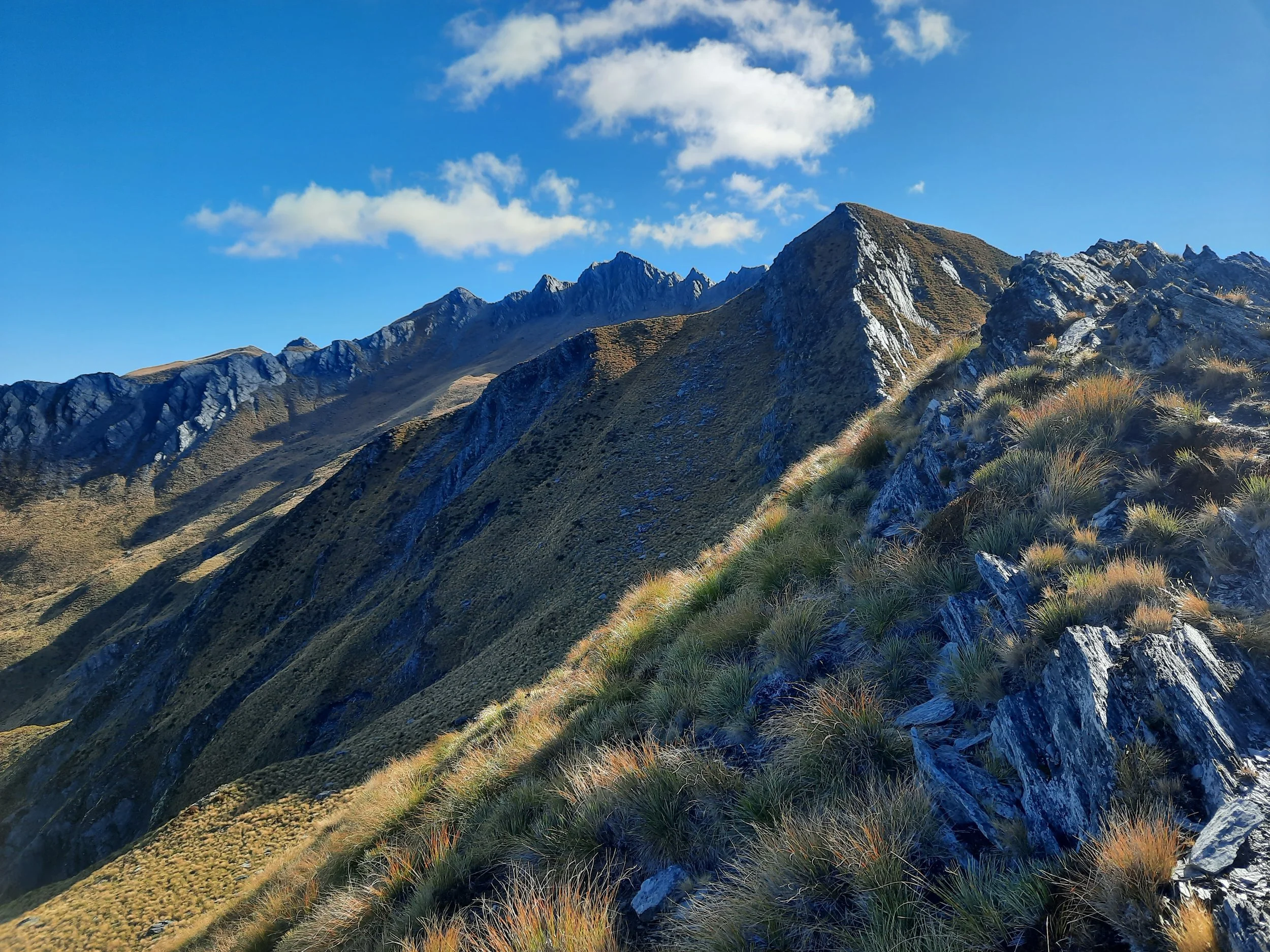
As the forest, clears, there is a fork. Going left took me uphill on an impact track. As Edward describes on HikingScenery.com, there is a difficult section of steep, loose terrain on the slopes approaching Point 1370. The route is on the north face of the ridge, rather than on top of the ridge or on the south face. Beyond that, I have little confidence about my route. So I’ve just put a purple question mark there on the topomap screenshot.
I know that I took a slightly different route back through the same area, because I remember jumping over a small gap I hadn’t encountered before. This demonstrates the difficulty of wayfinding. Even with a headlamp, I would be very unhappy to descend this area in the dark.
Above that tricky area, an impact track resumes - occasionally fading out or splitting in two.

Tripping hazard - a collapsed fence. Less visible in the afternoon shadow. Location is cyan line on topomap screenshot.
One spot troubled me on the way back. It is indicated with a cyan line on the topomap screenshot. There was a collapsed wire fence across the impact track. It was hard to see in the afternoon shadow. Someone could easily trip. I sent the Wānaka DOC an email, recommending they either set it standing up again, or make it more visible by spraypainting it a bright color.
That was April 2022. If you hike this route, let us know in the comments whether anything has changed.
On the topomap screenshot, just north of the cyan line, is a steep tussock-topped formation represented by oval contour lines. This is not part of the route to the summit. Scrambling up it would be challenging.
The summit is on top of a large, intimidating rock formation. There are several scree chutes in between solid parts jutting out of the rock formation.
To reach the summit, I climbed the scree chute recommended by Edward. Before my hike, a man I spoke to on top of Breast Hill agreed that that scree chute was an acceptable route to reach the summit; he also said there was another acceptable route on the far (western) end of the summit formation.
The scree chute was steep and loose, so I left my backpack behind. I have only done this a few other times. The descent was the more difficult part.
If 1 is an easy track, and 4 is using hands and feet on exposed rocks, I give this a 4 on the tricky section near Point 1370 (purple question mark), at the collapsed fence (cyan line), and on the rocky summit formation. The Sawyer Burn Track is a 1, because it is in good condition despite being steep. Most of the hike - the ridges and the tussock slopes - are a 2 or 3.


Without putting labels on the image, I don’t think I can identify peaks very well for you. But I will try a few.
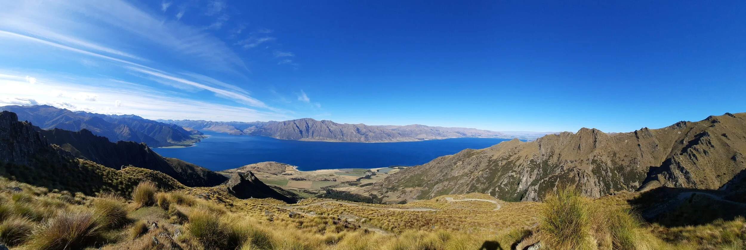
Lake Hāwea is on the left. Corner Peak is kind of at the corner, a bit shorter than Dingle Peak to its left. Breast Hill is barely visible to the right. Hāwea township and the agricultural land behind it (Hāwea Flat) are visible but faint, at the far end of the lake.
Isthmus Peak is in the center, on the Neck between the lakes.
Wānaka is at the far end of the other lake, not really visible. Nor is Roy’s Peak, just to the right, properly identifiable. But at far right, Mt Aspiring’s snowcapped spire can be seen.
North, east, south, west, and back to north.

Last light on Corner Peak (center), Dingle Peak (just left), and Breast Hill (right)
Hunting
The beginning and the end of the route are in hunting areas. Hunters are forbidden to “discharge firearms near tracks, huts, campsites, road-ends or any other public place.” I have hiked in more than 30 hunting areas, and only passed hunters twice - this wasn’t one of those hikes.
Here is the DOC topomap with all hunting areas visible.
Other pages about this hike
https://leeburty.com/leeburty/2014/02/22/sentinel-peak-hawea-conservation-park
https://www.facebook.com/runliketanya/videos/sentinel-peak-lake-hawea/403069410872420/
https://www.wildernessmag.co.nz/trip/sentinel-peak-hawea-conservation-park/
https://trekwithbeck.blog/2023/02/06/sentinel-peak-hike-wanaka/
Pages about the Sawyer Burn Track
Sentinel Peak seen from elsewhere


Sentinel Peak seen from Isthmus Peak (on the Neck between Lake Wānaka and Lake Hāwea). Sentinel Peak seems to be the highest peak at far left. Sawyers Bush Track climbs the forested spur just left of the lowest/nearest lakeshore green patch. From that spur, you can envision tracing the Sentinel Peak route to the left along the ridge.